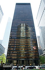
Seagram Building
 Seagram Building | |
| Państwo | |
|---|---|
| Stan | |
| Miejscowość | |
| Adres | 375 Park Avenue |
| Typ budynku | |
| Styl architektoniczny | |
| Architekt | |
| Wysokość całkowita | 157 m |
| Kondygnacje | 38 |
| Ukończenie budowy | 1958 |
| Pierwszy właściciel | Seagram |
Położenie na mapie stanu Nowy Jork (c) NordNordWest, CC BY 3.0 | |
| Strona internetowa | |
Seagram Building – wieżowiec biurowy w Nowym Jorku, w dzielnicy Midtown Manhattan. Budynek liczy 38 pięter i 157 m wysokości.
Seagram Building zbudowany został w latach 1954–1958 według projektu Ludwiga Miesa van der Rohe w stylu międzynarodowym. Budynek ma kształt prostopadłościanu a jego elewacja wykonana jest ze szkła i brązu. Przed wieżowcem znajduje się publiczny plac z dwiema fontannami. Projektantem holu oraz innych elementów wnętrza był Philip Johnson. Pierwszym właścicielem budynku było przedsiębiorstwo Seagram, produkujące napoje alkoholowe.
W 1984 roku Seagram Building otrzymał nagrodę Twenty-five Year Award przyznawaną przez organizację American Institute of Architects[1].
Przypisy
Bibliografia
- Seagram Building, [w:] Encyclopædia Britannica [online] [dostęp 2013-09-26] (ang.).
- AD Classics: Seagram Building / Mies van der Rohe. ArchDaily. [dostęp 2013-09-26]. (ang.).
- Seagram Building. New York Magazine. [dostęp 2013-09-26]. (ang.).
Media użyte na tej stronie
Autor: Alexrk2, Licencja: CC BY 3.0
Ta mapa została stworzona za pomocą GeoTools.
Autor: Uwe Dedering, Licencja: CC BY-SA 3.0
Location map of the USA (without Hawaii and Alaska).
EquiDistantConicProjection:
Central parallel:
* N: 37.0° N
Central meridian:
* E: 96.0° W
Standard parallels:
* 1: 32.0° N
* 2: 42.0° N
Made with Natural Earth. Free vector and raster map data @ naturalearthdata.com.
Formulas for x and y:
x = 50.0 + 124.03149777329222 * ((1.9694462586094064-({{{2}}}* pi / 180))
      * sin(0.6010514667026994 * ({{{3}}} + 96) * pi / 180))
y = 50.0 + 1.6155950752393982 * 124.03149777329222 * 0.02613325650382181
      - 1.6155950752393982  * 124.03149777329222 *
     (1.3236744353715044  - (1.9694462586094064-({{{2}}}* pi / 180))
      * cos(0.6010514667026994 * ({{{3}}} + 96) * pi / 180))
(c) NordNordWest, CC BY 3.0
Location map of the State of New York, USA
The flag of Navassa Island is simply the United States flag. It does not have a "local" flag or "unofficial" flag; it is an uninhabited island. The version with a profile view was based on Flags of the World and as a fictional design has no status warranting a place on any Wiki. It was made up by a random person with no connection to the island, it has never flown on the island, and it has never received any sort of recognition or validation by any authority. The person quoted on that page has no authority to bestow a flag, "unofficial" or otherwise, on the island.


