Seefeld in Tirol
| |||
 Seefeld in Tirol | |||
| |||
| Państwo | |||
|---|---|---|---|
| Kraj związkowy | |||
| Powiat | Innsbruck-Land | ||
| Powierzchnia | 17,38 km² | ||
| Wysokość | 1180 m n.p.m. | ||
| Populacja (1 stycznia 2015) • liczba ludności | 3369 | ||
| • gęstość | 194 os./km² | ||
| Numer kierunkowy | 05212 | ||
| Kod pocztowy | 6100 | ||
| Tablice rejestracyjne | IL | ||
| Strona internetowa | |||
Seefeld in Tirol – gmina w Austrii w kraju związkowym Tyrol, w powiecie Bezirk Innsbruck-Land. Ośrodek sportów zimowych.
W Seefeld in Tirol w 1963 odbyły się Mistrzostwa Świata w Biathlonie oraz konkursy skoków narciarskich i biegów na Zimowych Igrzyskach Paraolimpijskich w Innsbrucku. W gminie tej odbyły się także w 1985 Mistrzostwa Świata w Narciarstwie Klasycznym. Kolejne Mistrzostwa Świata w Narciarstwie Klasycznym odbyły się w tej gminie w 2019 roku[1].
Zobacz też
Przypisy
Linki zewnętrzne
Media użyte na tej stronie
Autor: Chianti, Licencja: CC BY-SA 3.0
Panoramic view of Seefeld in Tyrol in winter
Autor: Rosso Robot, Licencja: CC BY-SA 3.0
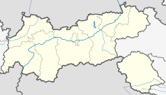
Location map of The Tyrol
Equirectangular projection. Geographic limits of the map:
- N: 47.75317° N
- S: 46.64119° N
- W: 10.08236° E
- E: 12.98961° E
Autor: Lencer, Licencja: CC BY-SA 3.0
Location map of Austria
Equirectangular projection, N/S stretching 150 %. Geographic limits of the map:
- N: 49.2° N
- S: 46.3° N
- W: 9.4° E
- E: 17.2° E
Autor: Adetaylor, Licencja: CC-BY-SA-3.0
Seefeld in Tirol, Austria
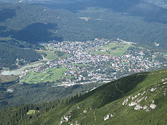
The three-pointed nature of the plateau is clearly visible. The valley to the left, next to the Wildsee lake, continues towards Innsbruck. (The leftmost edge of the photograph is more-or-less the watershed between the Inn, left/southwards and the Isar, right/northwards). The smaller valley also heading left goes towards Mösern. The Seekirchl (onion domed church) can be seen. The hill between the two is the Pfarrhügel; above it is the Gschwandkopf ski area (one of the pistes can be seen descending towards the Seekirchl). The right-hand edge of the photo shows the valley continuing northwards towards Scharnitz and, ultimately, Germany. This photograph was taken from the edge of the Reitherspitze; one of the largest mountains that dominate the Seefeld plateau, in the Karwendel range.
Other visible features include the golf academy (a larger golf course is not visible in the woods) and rolling hills heading towards the Leutasch valley. These wooded hills are one of the things that makes the area more varied than a typical valley-bottom mountain resort.


