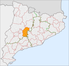
Segarra
| |||
(c) Joan M. Borràs (ebrenc), CC BY-SA 2.5 Położenie Segarra na mapie Katalonii | |||
| |||
| Państwo | |||
| Wspólnota autonomiczna | |||
| Prowincja | Lleida | ||
| Comarca | Segarra | ||
| Powierzchnia | 722,8 km² | ||
| Populacja • liczba ludności • gęstość | 20 996 29 os./km² | ||
| 41°44′21″N 1°19′55″E/41,739167 1,331944 | |||
| Portal | |||
Segarra – comarca (powiat) leżąca w Hiszpanii w środkowej części regionu Katalonia. Zajmuje powierzchnię 722,8 km² i liczy 20 996 mieszkańców. Siedzibą comarki jest Cervera.
Gminy
- Biosca
- Cervera
- Estaràs
- Granyanella
- Granyena de Segarra
- Guissona
- Ivorra
- Massoteres
- Montoliu de Segarra
- Montornès de Segarra
- Les Oluges
- Els Plans de Sió
- Ribera d'Ondara
- Sanaüja
- Sant Guim de Freixenet
- Sant Guim de la Plana
- Sant Ramon
- Talavera
- Tarroja de Segarra
- Torà
- Torrefeta i Florejacs
Linki zewnętrzne
Media użyte na tej stronie
Location map of Catalonia. Equirectangular projection, N/S stretching 130 %. Geographic limits of the map: * N: 42.99° N * S: 40.405° N * W: 0.55° O * E: 4.02° O
Autor: NordNordWest, Licencja: CC BY-SA 3.0
Location map of Spain
Equirectangular projection, N/S stretching 130 %. Geographic limits of the map:
- N: 44.4° N
- S: 34.7° N
- W: 9.9° W
- E: 4.8° E
Autor: Pedro A. Gracia Fajardo, escudo de Manual de Imagen Institucional de la Administración General del Estado, Licencja: CC0
Flaga Hiszpanii
The senyera, a flag of Catalonia, and also used by several lands and municipalities of the ancient Crown of Aragon
Autor: Heralder, Licencja: CC BY-SA 3.0
Coat of arms of the Segarra, Catalonia (Spain)


