Selkirk Mountains
 Mount MacDonald | |
| Kontynent | |
|---|---|
| Państwo | |
| Najwyższy szczyt | Mount Sir Sandford |
| Długość | 525 km |
| Jednostka dominująca | |
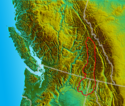
 Położenie Gór Selkirk na mapie USA i Kanady | |
Selkirk Mountains (ang. Selkirk Mountains) – pasmo górskie położone w górach Columbia Mountains o długości ok. 320 km. Rozciąga się od południowej części kanadyjskiej prowincji Kolumbia Brytyjska aż na teren Stanów Zjednoczonych do stanów Idaho i Waszyngton. Największym szczytem pasma jest Mount Sir Sandford – 3519 m n.p.m.[1]. Góry nazwano na cześć Thomasa Douglasa, piątego earla Selkirk[2].
Historia
Po raz pierwszy uznane zostały za odrębne pasmo górskie w roku 1807 przez Davida Thompsona, kartografa handlującej futrami Kompanii Północno-Zachodniej i nazywane były wówczas Nelson Mountains[1]. Podczas budowy kolei stanowiły jedną z najcięższych zapór, dopiero odkrycie przełączy Rogers Pass umożliwiło przeprowadzenie linii kolejowej. W 1857 w rejonie pasma odkryto złoto.
Najwyższe szczyty
Znaczna część najwyższego pasma pasma Selkirk objęta jest Parkiem Narodowym Glacier. Pozostałe wysokie szczyty znajdują się na północy pasma w miejscu połączenia z główną częścią Columbia Mountains[3].
- Mount Sir Sandford - 3519 m n.p.m. (Północne Selkirk Mountains)
- Mount Dawson - 3377 m n.p.m. (Park Narodowy Glacier)
- Mount Selwyn - 3355 m n.p.m. (Park Narodowy Glacier)
- Adamant Mountain - 3345 m n.p.m. (Północne Selkirk Mountains)
- Austerity Mountain - 3337 m n.p.m. (Północne Selkirk Mountains)
- Mount Wheeler - 3336 m n.p.m. (Park Narodowy Glacier)
- Grand Mountain - 3287 m n.p.m. (Park Narodowy Glacier)
- Mount Sir Donald - 3284 m n.p.m. (Park Narodowy Glacier)
- Iconoclast Mountain - 3236 m n.p.m. (Park Narodowy Glacier)
- Mount Kilpatrick - 3224 m n.p.m. (Park Narodowy Glacier)
- Abercrombie Mountain - 2227 m n.p.m.
Przypisy
- ↑ a b Selkirk Mountains (Selkirks). bivouac.com, 2012-06-03. (ang.).
- ↑ Selkirk Mountains, [w:] Encyclopædia Britannica [online] [dostęp 2016-03-02] (ang.).
- ↑ Selkirk Mountains. peakbagger.com. [dostęp 2016-03-02]. (ang.).
Media użyte na tej stronie
The flag of Navassa Island is simply the United States flag. It does not have a "local" flag or "unofficial" flag; it is an uninhabited island. The version with a profile view was based on Flags of the World and as a fictional design has no status warranting a place on any Wiki. It was made up by a random person with no connection to the island, it has never flown on the island, and it has never received any sort of recognition or validation by any authority. The person quoted on that page has no authority to bestow a flag, "unofficial" or otherwise, on the island.
Black up-pointing triangle ▲, U+25B2 from Unicode-Block Geometric Shapes (25A0–25FF)
Autor: Uwe Dedering, Licencja: CC BY-SA 3.0
Relief location map of North America.
- Projection: Lambert azimuthal equal-area projection.
- Area of interest:
- N: 90.0° N
- S: 5.0° N
- W: -140.0° E
- E: -60.0° E
- Projection center:
- NS: 47.5° N
- WE: -100.0° E
- GMT projection: -JA-100/47.5/20.0c
- GMT region: -R-138.3726888474925/-3.941007863604182/2.441656573833029/50.63933645705661r
- GMT region for grdcut: -R-220.0/-4.0/20.0/90.0r
- Relief: SRTM30plus.
- Made with Natural Earth. Free vector and raster map data @ naturalearthdata.com.
Autor: The Interior, Licencja: CC BY-SA 3.0
Mount MacDonald in the Selkirk Mountains of British Columbia, Canada.
adapted from img in Wikimedia Commons File:South BC-NW USA-relief.png


