Shepherd’s Bush
| Dzielnica Londynu | |
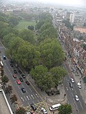
 Widok na centrum w kierunku Acton | |
| Państwo | |
|---|---|
| Kraj | |
| Region | |
| Miasto | |
| Gmina | |
Położenie na mapie Wielkiego Londynu Contains Ordnance Survey data © Crown copyright and database right, CC BY-SA 3.0 | |
Położenie na mapie Wielkiej Brytanii (c) Karte: NordNordWest, Lizenz: Creative Commons by-sa-3.0 de | |
| 51°30′15″N 0°13′15″W/51,504200 -0,220700 | |
| Portal | |
Shepherd’s Bush – dzielnica Londynu położona 8 km na północny zachód od Charing Cross w okręgu London Borough of Hammersmith and Fulham w hrabstwie ceremonialnym Wielki Londyn. Jest zarówno dzielnicą mieszkalną, jak i centrum handlowym. Jest siedzibą klubu piłkarskiego Queens Park Rangers[1]
Przypisy
- ↑ Queen’s Park Rangers F.C, Shepherds Bush, London. [dostęp 2009-11-09]. (ang.).
Media użyte na tej stronie
Contains Ordnance Survey data © Crown copyright and database right, CC BY-SA 3.0
Map of Greater London, UK with the following information shown:
- Administrative borders
- Coastline, lakes and rivers
- Roads and railways
- Urban areas
The data includes both primary routes and railway lines.
Equirectangular map projection on WGS 84 datum, with N/S stretched 160%
Geographic limits:
- West: 0.57W
- East: 0.37E
- North: 51.72N
- South: 51.25N
(c) Karte: NordNordWest, Lizenz: Creative Commons by-sa-3.0 de
Location map of the United Kingdom
Flag of England. Saint George's cross (a red cross on a white background), used as the Flag of England, the Italian city of Genoa and various other places.
Shepherd's Bush Green, early morning, looking northwest towards Acton. Taken from the 19th floor of a nearby residential block. (September 2006)


