Shepton Mallet
| ||
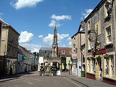
 Rynek w Shepton Mallet | ||
| Państwo | ||
| Kraj | ||
| Region | South West | |
| Hrabstwo | Somerset | |
| Dystrykt | Mendip | |
| Wysokość | 20 m n.p.m. | |
| Populacja (2002) • liczba ludności | 8 440 | |
| Nr kierunkowy | 01749 | |
| Kod pocztowy | BA4 | |
Położenie na mapie Somersetu Contains Ordnance Survey data © Crown copyright and database right, CC BY-SA 3.0 | ||
Położenie na mapie Wielkiej Brytanii (c) Karte: NordNordWest, Lizenz: Creative Commons by-sa-3.0 de | ||
| Strona internetowa | ||
| Portal | ||
Shepton Mallet – niewielkie miasto w Wielkiej Brytanii, w Anglii, w hrabstwie Somerset, we wschodniej jego części u podnóża wzgórz Mendip. Jest siedzibą władz dystryktu Mendip. W pobliżu kilka jaskiń.
W Wielkiej Brytanii miasto stało się znane po tym, gdy w roku 2006 grupa 30 mieszkańców zaprotestowała przeciwko wybudowaniu supermarketu sieci handlowego Tesco na obrzeżach miasta, co zniszczyłoby dziewiętnastowieczne drzewa[1].
Miasta partnerskie
Przypisy
- ↑ Oliver Duff: Tree protesters take on the might of Tesco (ang.). The Independent, 2006-02-25. [dostęp 2010-11-17].
Media użyte na tej stronie
Contains Ordnance Survey data © Crown copyright and database right, CC BY-SA 3.0
Map of Somerset, UK with the following information shown:
- Administrative borders
- Coastline, lakes and rivers
- Roads and railways
- Urban areas
Equirectangular map projection on WGS 84 datum, with N/S stretched 155%
Geographic limits:
- West: 3.96W
- East: 2.12W
- North: 51.55N
- South: 50.80N
(c) Karte: NordNordWest, Lizenz: Creative Commons by-sa-3.0 de
Location map of the United Kingdom
Flag of England. Saint George's cross (a red cross on a white background), used as the Flag of England, the Italian city of Genoa and various other places.
Autor: Wurzeller, Licencja: CC BY-SA 3.0
The car-free marketplace and floral decorations of Shepton Mallet, a small town on the edge of the Mendip Hills in Somerset, UK. The town is marked in the Domesday Book of 1086 and successive market charters were granted in 1235, 1260 and 1318. The principal industry was the wool trade through the Middle Ages; later, brewing and shoemaking became important. The market cross is a fine example of its type; nearby are preserved butcher's market stalls known as the Shambles. Picture taken by wurzeller on 14 June 2008


