Shropshire (dystrykt)
| unitary authority | |
 Shrewsbury | |
| Państwo | |
|---|---|
| Kraj | |
| Region | |
| Hrabstwo | |
| Powierzchnia | 3197 km²[1] |
| Populacja (2011) • liczba ludności |
|
| • gęstość | 96 os./km²[2] |
Położenie na mapie Wielkiej Brytanii (c) Karte: NordNordWest, Lizenz: Creative Commons by-sa-3.0 de | |
| 52,708056°N 2,754444°W/52,708056 -2,754444 | |
| Portal | |
Shropshire – dystrykt (unitary authority)[3] w hrabstwie ceremonialnym Shropshire w Anglii. W 2011 roku dystrykt liczył 306 129 mieszkańców[4].
Przypisy
- ↑ Shropshire, [w:] Encyclopædia Britannica [online] [dostęp 2022-10-05] (ang.).
- ↑ The Guardian
- ↑ Ordnance Survey linked data
- ↑ Neighbourhood Statistics
Media użyte na tej stronie
(c) Karte: NordNordWest, Lizenz: Creative Commons by-sa-3.0 de
Location map of the United Kingdom
Flag of England. Saint George's cross (a red cross on a white background), used as the Flag of England, the Italian city of Genoa and various other places.
Autor:
- Shrewsburycathedral.JPG: Fountain Posters
- derivative work: Rabanus Flavus
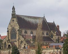
Shrewsbury Cathedral in Town Walls, Shrewsbury, Shropshire, England, UK. Image shows town walls in foreground.


