Shuttle Landing Facility
 | |||
| Państwo | |||
|---|---|---|---|
| Miejscowość | Merrit Island, Floryda (część Centrum Kosmicznego im. JFK) | ||
| Typ | cywilne | ||
| Właściciel | |||
| Kod IATA | QQS | ||
| Kod ICAO | KTTS | ||
| Wysokość | 3 m n.p.m. | ||
| Drogi startowe | |||
| |||
| Strona internetowa | |||
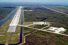
Shuttle Landing Facility (kod IATA: QQS, kod ICAO: KTTS) – należące do NASA lotnisko będące częścią Centrum Kosmicznego im. JFK, wykorzystywane do lądowań promów kosmicznych do zakończenia programu lotów wahadłowców w 2011, a także do startów i lądowań samolotów treningowych i cywilnych, w tym B-747 SCA.
Opis
Samo lotnisko zajmuje obszar o powierzchni 200 ha. Posiada jedynie pas o kierunkach 15 i 33. Pas ma długość 4572 m i szerokość 91,4 m. Nawierzchni pasa jest wykonana z betonu, co pozwala na większą siłę tarcia powodującą hamowanie promu. W celu wykorzystania samolotu przenoszącego promy (nosiciela wahadłowców) wykorzystywano znajdujący się na terenie lotniska dźwig umożliwiający zamocowanie promu na grzbiecie nosiciela.
Pierwszym lotem programu wahadłowców, który wylądował na SLF, był lot STS-41-B. Lądowanie nastąpiło 11 lutego 1984. Poprzednie loty wahadłowców wykorzystywały do lądowania pasy w Edwards AFB (wyjątkiem był lot STS-3).
Oprócz obsługi wahadłowców SLF wykorzystywana jest do komercyjnych zastosowań, np. firma Zero Gravity Corporation wykorzystuje pas lotniska do startów samolotów, w których pasażerowie mogą odczuć działanie zerowej grawitacji.
Ekipy NASCAR wykorzystują pas SLF do testowania pojazdów.
Zobacz też
Bibliografia
- Shuttle Landing Facility. www-pao.ksc.nasa.gov. [zarchiwizowane z tego adresu (2011-02-05)]. - NASA.gov fact sheet
- Space Shuttle Era: Landing Sites - NASA video on YouTube
Media użyte na tej stronie
Autor: Uwe Dedering, Licencja: CC BY-SA 3.0
Location map of the USA (without Hawaii and Alaska).
EquiDistantConicProjection:
Central parallel:
* N: 37.0° N
Central meridian:
* E: 96.0° W
Standard parallels:
* 1: 32.0° N
* 2: 42.0° N
Made with Natural Earth. Free vector and raster map data @ naturalearthdata.com.
Formulas for x and y:
x = 50.0 + 124.03149777329222 * ((1.9694462586094064-({{{2}}}* pi / 180))
      * sin(0.6010514667026994 * ({{{3}}} + 96) * pi / 180))
y = 50.0 + 1.6155950752393982 * 124.03149777329222 * 0.02613325650382181
      - 1.6155950752393982  * 124.03149777329222 *
     (1.3236744353715044  - (1.9694462586094064-({{{2}}}* pi / 180))
      * cos(0.6010514667026994 * ({{{3}}} + 96) * pi / 180))
The flag of Navassa Island is simply the United States flag. It does not have a "local" flag or "unofficial" flag; it is an uninhabited island. The version with a profile view was based on Flags of the World and as a fictional design has no status warranting a place on any Wiki. It was made up by a random person with no connection to the island, it has never flown on the island, and it has never received any sort of recognition or validation by any authority. The person quoted on that page has no authority to bestow a flag, "unofficial" or otherwise, on the island.
Symbol lotniska do legendy mapy
SVG version of PNG Space Shuttle Logo/Patch.
This aerial photo of the runway at the KSC Shuttle Landing Facility looks northwest. Longer and wider than most commercial runways, it is about 15,000 feet long, with 1,000-foot paved overruns on each end, and 300 feet wide, with 50-foot asphalt shoulders. The runway is used by military and civilian cargo carriers, astronauts’ T-38 trainers, Shuttle Training Aircraft and helicopters, as well as the Space Shuttle. At center right is the parking apron with the orbiter mate/demate tower. The tow-way stretches from the runway to the right, passing the hangar and storage facilities. A grassy area next to the mid-point of the runway is where the new control tower is located.


