Sierra de las Ánimas
 Góra Cerro Pan de Azúcar w Sierra de las Ánimas | |
| Kontynent | |
|---|---|
| Państwo | |
| Najwyższy szczyt | |
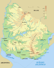
 Mapa fizyczna Urugwaju. Na południu mieści się pasmo Sierra de las Ánimas | |
| 34°45′07″S 55°19′11″W/-34,752050 -55,319594 | |
Sierra de las Ánimas - pasmo górskie w Urugwaju, mieszczące się w Departamencie Maldonado, będące częścią pasma Cuchilla Grande. Najwyższym szczytem gór jest Cerro de las Ánimas, liczące 501 m n.p.m.
Góry są zbudowane z granitów i gnejsów. Pasmo to powstało w prekambrze.
Współrzędne geograficzne: 34° 48'33 "S 58° 15'31" W
Linki zewnętrzne
Bibliografia
- Enciclopedia Geografica del Uruguay. [dostęp 2012-07-18]. (hiszp.).
Media użyte na tej stronie
Black up-pointing triangle ▲, U+25B2 from Unicode-Block Geometric Shapes (25A0–25FF)
Autor: Hoverfish, Licencja: CC BY-SA 3.0
The east slope of Cerro Pan de Azúcar seen from the Reserva de Flora y Fauna del Pan de Azúcar (nature reserve), Maldonado Department, Uruguay.
Topographical map of Uruguay
Autor: Dr Brains, Licencja: GFDL
Location map of Uruguay
Equirectangular projection, Geographic limits of the map:
- N: 29.86° S
- S: 35.19° S
- W: 58,71° W
- E: 52,89° W


