Sierre
 | |||
| |||
| Państwo | |||
|---|---|---|---|
| Kanton | |||
| Gmina | Sierre | ||
| SFOS | 6248 | ||
| Burmistrz | François Genoud | ||
| Wysokość | 533 m n.p.m. | ||
| Populacja (2012) • liczba ludności • gęstość |
| ||
| Nr kierunkowy | 027 | ||
| Kod pocztowy | 3960 | ||
| Tablice rejestracyjne | VS | ||
 | |||
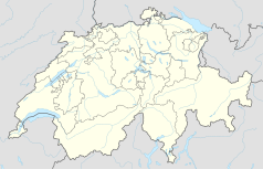
Położenie na mapie Szwajcarii (c) Karte: NordNordWest, Lizenz: Creative Commons by-sa-3.0 de | |||
| Strona internetowa | |||
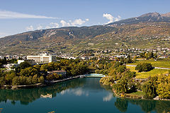
Sierre (niem. Siders) – miasto w Szwajcarii położone w dolinie rzeki Rodan w kantonie Valais/Wallis. Stolica dystryktu Sierre.
Jest miastem dwujęzycznym (za sprawą mniejszości niemieckojęzycznej), jednym z trzech oficjalnych dwujęzycznych miast Szwajcarii. Leży na styku obszaru francusko i niemieckojęzycznego.
Przez miasto przebiega autostrada nr 9 oraz linia kolejowa Martigny-Brig. Funkcjonuje tu najdłuższa na świecie kolej linowo-terenowa – Montana-Vermala.
Sport
- HC Sierre – klub hokeja na lodzie
Media użyte na tej stronie
Flag of Canton of Valais (Switzerland). The black contours around the stars and along the division of the field are not usually seen in cantonal flags and are an artefact of this representation reflecting the image used for the pdf of the federal Fahnenreglement of 2007.
Autor: Template:Bild-picswiss, Licencja: CC-BY-SA-3.0
Der Grand-Lac (Lac de Géronde) in Sierre
Autor:
- File:Wappen Schild Blank.svg: UnreifeKirsche, OwenBlacker
- File:Sol de Mayo-Bandera de Argentina.svg: Pumbaa80, TigerTjäder
Coat of arms of Sierre, Valais: Gules, a sun resplendent Or
Autor: Abaddon1337, Licencja: CC BY-SA 3.0
Fork from media:Karte Kanton Wallis Bezirke 2010.png for geolocalisation
(c) Karte: NordNordWest, Lizenz: Creative Commons by-sa-3.0 de
Location map of Switzerland


