Siewierouralsk
 | |||||
| Państwo | |||||
|---|---|---|---|---|---|
| Obwód | |||||
| Populacja (2010) • liczba ludności |
| ||||
| Nr kierunkowy | +7 34380 | ||||
| Kod pocztowy | 624480 | ||||
| Tablice rejestracyjne | 66 | ||||
| Strona internetowa | |||||
| Portal | |||||
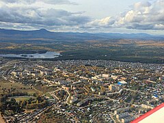
Siewierouralsk (ros. Североуральск) – miasto w Rosji w bezpośrednim podporządkowaniu obwodu swierdłowskiego.
Geografia
Położone nad brzegami Wagranu w odległości 512 km od Jekaterynburga. W 2005 roku liczyło 33,5 tys. mieszkańców. Centrum wydobycia i przerobu boksytu. Prawa miejskie od 1944.
Znajduje się tu dyrekcja Rezerwatu przyrody „Dienieżkin Kamien´”[2].
Historia
Powstało w 1758 roku jako osiedle budowniczych zakładów metalurgicznych – Pietropawłowskij. W 1944 wraz z nadaniem praw miejskich zmieniono nazwę na Siewierouralsk.
Przypisy
Media użyte na tej stronie
Autor: Uwe Dedering, Licencja: CC BY-SA 3.0
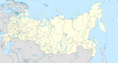
Location map of Russia.
EquiDistantConicProjection : Central parallel :
* N: 54.0° N
Central meridian :
* E: 100.0° E
Standard parallels:
* 1: 49.0° N
* 2: 59.0° N
Made with Natural Earth. Free vector and raster map data @ naturalearthdata.com.
Because the southern Kuril islands are claimed by Russia and Japan, they are shown as disputed. For more information about this see: en:Kuril Islands dispute. These islands are since 1945 under the jurisdiction of the Russian Federation.
Severouralsk (Sverdlovsk oblast), coat of arms
Severouralsk (Sverdlovsk oblast), flag
Map of Sverdlovskaya oblast (Russia), in the Mercator projection.


