Sint Maarten (terytorium)
| |||||
| Dewiza: (łac.) Semper pro grediens (Zawsze postępująca) | |||||
| Hymn: O Sweet Saint Martin’s Land | |||||
 | |||||
| Język urzędowy | |||||
|---|---|---|---|---|---|
| Stolica | |||||
| Ustrój polityczny | autonomiczny kraj wchodzący w skład Królestwa Niderlandów | ||||
| Typ państwa | |||||
| Głowa państwa | |||||
| Zależne od | |||||
| W jego imieniu | gubernator Eugene Holiday | ||||
| Szef rządu | premier Leona Marlin-Romeo | ||||
| Powierzchnia • całkowita |
| ||||
| Liczba ludności (2017) • całkowita • gęstość zaludnienia |
| ||||
| Waluta | Gulden antylski (ANG) | ||||
| Strefa czasowa | UTC -4 | ||||
| Domena internetowa | .sx | ||||
| Kod telefoniczny | 1(721) | ||||
 | |||||


Sint Maarten – terytorium zależne Holandii (de iure autonomiczny kraj wchodzący w skład Królestwa Niderlandów) położone w Małych Antylach, zajmujące południową część wyspy o tej samej nazwie. Do 10 października 2010 roku jedna z pięciu jednostek administracyjnych (eilandgebied) wchodzących w skład Antyli Holenderskich; na podstawie reformy konstytucyjnej Królestwa Niderlandów, 10 października 2010 roku Antyle Holenderskie przestały istnieć, a Sint Maarten stało się osobnym terytorium zależnym Holandii o specjalnym statusie.
Powierzchnia Sint Maarten wynosi 34 km², a zamieszkuje ją ok. 35 000 osób. Językiem urzędowym jest niderlandzki, lecz powszechnie używany jest język angielski. Stolicą jest miasto Philipsburg liczące ok. 1300 mieszkańców.
Domeną internetową dla Sint Maarten jest .sx.
Geografia
Sint Maarten zajmuje południową część wyspy Sint Martin, która cechuje się górzystym krajobrazem. Tereny obejmujące wyspę wznoszą się jedynie na 300-400 m n.p.m. a krajobraz w niektórych miejscach jest wybitnie nizinny. Na terytorium Sint Maarten jak i całej wyspy panuje równikowy klimat. Roślinność jest w znacznym stopniu wyniszczona, gdzie znaczne tereny zajmuje zabudowa miejska i tereny rolnicze. Rosną niewielkie fragmenty lasów tropikalnych. Wyspę otaczają rafy koralowe. Co roku region nawiedzają cyklony tropikalne.
Przez wyspę przebiega granica lądowa z francuskim terytorium Saint-Martin.

Międzynarodowy port lotniczy Princess Juliana - główny port lotniczy wyspy
 (c) giggel, CC BY 3.0
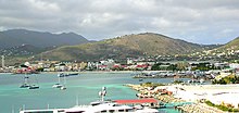
Widok na miejscowości m.in. Cole Bay, Simpson Bay, w kierunku lotniska
Philipsburg stolica i główne miasto na wyspie Sint Maarten
Religia
- protestantyzm – 41,9%:
- zielonoświątkowcy – 14,7%
- metodyści – 10%
- adwentyści dnia siódmego – 6,6%
- baptyści – 4,7%
- anglikanie – 3,1%
- katolicyzm – 33,1%
- hinduizm – 5,2%
- chrześcijaństwo (nieokreśleni) – 4,1%
- Świadkowie Jehowy – 1,7% (zobacz: Świadkowie Jehowy na Sint Maarten)
- ewangelikalizm (nieokreśleni) – 1,4%
- islam/judaizm – 1,1%
- inne religie – 1,3%
- brak religii – 7,9%
- brak odpowiedzi – 2,4%.
Przypisy
- ↑ The World Factbook — Central Intelligence Agency, www.cia.gov [dostęp 2017-10-03] [zarchiwizowane z adresu 2019-12-28] (ang.).
Media użyte na tej stronie

.svg)
Autor: Heraldry, Licencja: CC-BY-SA-3.0
North America (orthographic projection)

The flag of Aruba


The flag of Curaçao is a blue field with a horizontal yellow stripe slightly below the midline and two white, five-pointed stars in the canton. The geometry and colors are according to the description at Flags of the World.


Coat of arms of Sint Maarten
Saint Martin - NASA NLT Landsat 7 (Visible Color) Satellite Image
.jpg)
(c) giggel, CC BY 3.0
St. Maarten, Karibik - Look at the Cole Bay, Lay Bay and Simpson Bay
.jpg)
Autor: roger4336, Licencja: CC BY-SA 2.0
Philipsburg, Sint Maarten, from Celebrity Equinox. This closeup photo shows the areas where I walked on this cruise and in 2004.
The orange roof in the foreground is one of the three stops of the "water taxi" for cruise passengers and others. The other stops are Captain Hodge Pier at the far left and an inlet in the right hand corner of Grand Bay. The Courthouse is near Captain Hodge Pier.
Part of the huge yacht Attessa IV is in the immediate foreground._AN1011997.jpg)
Autor: