Smoky Hill (rzeka)
 Rzeka Smoky Hill w dolnym biegu | |
| Kontynent | |
|---|---|
| Państwo | |
| Lokalizacja | |
| Długość | 900 km |
| Źródło | |
| Miejsce | hrabstwo Cheyenne |
| Wysokość | 1410 m n.p.m. |
| Współrzędne | |
| Ujście | |
| Recypient | rzeka Kansas |
| Miejsce | koło Junction City |
| Wysokość | 320 m n.p.m. |
| Współrzędne | |
| Mapa | |
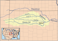
 Mapa dorzecza | |
Smoky Hill (ang. Smoky Hill River) – rzeka w Stanach Zjednoczonych, w stanach Kolorado i Kansas, jedna z rzek źródłowych rzeki Kansas. Długość rzeki wynosi około 900 km[1].
Źródło rzeki znajduje się na terenie hrabstwa Cheyenne, na wysokości około 1410 m n.p.m. Rzeka płynie w kierunku wschodnim. W pobliżu miasta Junction City, na wysokości 320 m n.p.m. łączy się z rzeką Republican, dając początek rzece Kansas[1][2][3].
Głównymi dopływami są North Fork Smoky Hill (ujście na zachód od Russell Springs), Saline (ujście na wschód od Salina) i Solomon (ujście koło Solomon)[1][2].
Większe miasta położone nad rzeką to Ellsworth, Lindsborg, Salina, Abilene i Junction City[2].
Przypisy
- ↑ a b c Smoky Hill River, [w:] Encyclopædia Britannica [online] [dostęp 2018-05-28] (ang.).
- ↑ a b c TopoView. U.S. Geological Survey. [dostęp 2018-05-28]. (ang.).
- ↑ Smoky Hill River. Geographic Names Information System (GNIS). [dostęp 2018-05-28]. (ang.).
Media użyte na tej stronie
Autor: Uwe Dedering, Licencja: CC BY-SA 3.0
Relief location map of the USA (without Hawaii and Alaska).
EquiDistantConicProjection : Central parallel :
* N: 37.0° N
Central meridian :
* E: 96.0° W
Standard parallels:
* 1: 32.0° N
* 2: 42.0° N
Made with Natural Earth. Free vector and raster map data @ naturalearthdata.com.
Formulas for x and y:
x = 50.0 + 124.03149777329222 * ((1.9694462586094064-({{{2}}}* pi / 180))
      * sin(0.6010514667026994 * ({{{3}}} + 96) * pi / 180))
y = 50.0 + 1.6155950752393982 * 124.03149777329222 * 0.02613325650382181
      - 1.6155950752393982  * 124.03149777329222 *
     (1.3236744353715044  - (1.9694462586094064-({{{2}}}* pi / 180))
      * cos(0.6010514667026994 * ({{{3}}} + 96) * pi / 180))
The flag of Navassa Island is simply the United States flag. It does not have a "local" flag or "unofficial" flag; it is an uninhabited island. The version with a profile view was based on Flags of the World and as a fictional design has no status warranting a place on any Wiki. It was made up by a random person with no connection to the island, it has never flown on the island, and it has never received any sort of recognition or validation by any authority. The person quoted on that page has no authority to bestow a flag, "unofficial" or otherwise, on the island.
Photo of the Smoky Hill River from the stream gauge station located at 38.711111° N, Longitude: 97.571389 W, Horizontal Datum: NAD27. Photo captioned "Looking downstream, stage 3.17 ft".


