Sohland an der Spree
| gmina | |||
 | |||
| |||
| Państwo | |||
|---|---|---|---|
| Kraj związkowy | |||
| Powiat | |||
| Powierzchnia | 37,27 km² | ||
| Wysokość | 302 m n.p.m. | ||
| Populacja (31 grudnia 2009) • liczba ludności |
| ||
| • gęstość | 195 os./km² | ||
| Numer kierunkowy | 035936 | ||
| Kod pocztowy | 02686-02689 | ||
| Tablice rejestracyjne | BZ, BIW, HY, KM | ||
Adres urzędu: Bahnhofstraße 2602689 Sohland an der Spree | |||
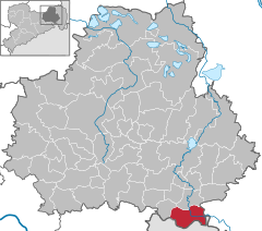
Położenie na mapie powiatu | |||
| 51°03′N 14°26′E/51,050000 14,433333 | |||
| Strona internetowa | |||
| Portal | |||
Sohland an der Spree (górnołuż. Załom) – miejscowość i gmina w Niemczech, w kraju związkowym Saksonia, w okręgu administracyjnym Drezno, w powiecie Budziszyn.
Współpraca
Miejscowości partnerskie[1]:
Zobacz też
Bibliografia
- Statistisches Landesamt des Freistaates Sachsen, Kamenz, 2009
Przypisy
Media użyte na tej stronie
The historical coat of arms of Upper Lusatia and the city of Bautzen in Saxony, Germany. Today this is the coat of arms of the district Bautzen.
Autor: Dummkopf, Licencja: CC BY 3.0
Markt mit Kirche in Sohland
|
|
|
|
|
|
|
|


