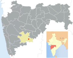
Solapur (dystrykt)
| Dystrykt | |
| Państwo | |
|---|---|
| Stan | |
| Region | Western Maharashtra |
| Siedziba | |
| Powierzchnia | 14 895 km² |
| Populacja (2003) • liczba ludności |
|
| • gęstość | 259 os./km² |
| Szczegółowy podział administracyjny | |
| Liczba poddystryktów | 3 |
| Liczba tahsili | 11 |
Położenie na mapie | |
Solapur (dystrykt) (marathi सोलापूर जिल्हा, ang. Solapur district) – jest jednym z trzydziestu pięciu dystryktów indyjskiego stanu Maharasztra, o powierzchni 14 895 km².
Położenie
Położony jest na południu tego stanu. Graniczy z dystryktami: od zachodu z Pune, Sangli, od północy z Ahmednagar, Osmanabad, od wschodu z Osmanabad a od południa ze stanem Karnataka.
Stolicą dystryktu jest miasto Solapur.
Rzeki
Rzeki przepływające przez obszar dystryktu :
- Bhima
- Bhogawati
- Bori
- Harni
- Man
- Nira
- Sina
Bibliografia
- P.S Deshpande, Ramesh Sawant: Road Atlas of Maharashtra. Aurangabad: Samarth Udyog Prakashan, 2003, s. 23. ISBN 81-87551-09-7. (ang.)
Media użyte na tej stronie
The Flag of India. The colours are saffron, white and green. The navy blue wheel in the center of the flag has a diameter approximately the width of the white band and is called Ashoka's Dharma Chakra, with 24 spokes (after Ashoka, the Great). Each spoke depicts one hour of the day, portraying the prevalence of righteousness all 24 hours of it.
Autor:
- Maharashtra_-_Pune.png: *Maharashtra_locator_map.svg: PlaneMad
- India_Maharashtra_locator_map.svg: PlaneMad
- derivative work: Abhijitsathe (talk)
- derivative work: Abhijitsathe (talk)
Location of Solapur in Maharashtra, India

