Somerville (New Jersey)
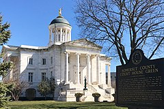
 Siedziba władz hrabstwa Somerset | |
| Państwo | |
|---|---|
| Stan | |
| Hrabstwo | |
| Powierzchnia | 6,0[1] km² |
| Populacja (2018) • liczba ludności • gęstość |
|
| Kod pocztowy | 08876 |
| Strona internetowa | |
| Portal | |
Somerville – miejscowość (borough), ośrodek administracyjny hrabstwa Somerset, w północnej części stanu New Jersey, w Stanach Zjednoczonych, położona na północnym brzegu rzeki Raritan[2], na zachodnim obrzeżu obszaru metropolitalnego Nowego Jorku. W 2018 roku miejscowość liczyła 12 202 mieszkańców[1].
Początki miejscowości sięgają około 1680 roku, kiedy to osiedli tu holenderscy osadnicy. Nazwę Somerville osada przyjęła w 1801 roku. Formalne założenie miejscowości miało miejsce w 1864 roku, obecny status borough otrzymała ona w 1909 roku[2].
Znajduje się tu zabytkowy dom Wallace House z 1776 roku, gdzie zimą 1778/1779, podczas rewolucji amerykańskiej, przebywał George Washington[2]. W sąsiedztwie znajduje się budynek plebanii Old Dutch Parsonage z 1751 roku, miejsce zamieszkania Jacoba Hardenbergha, pierwszego rektora uczelni Queen's College, w późniejszych latach przekształconej w Uniwersytet Rutgersa[3].
Przypisy
- ↑ a b c QuickFacts: Somerville borough, New Jersey. U.S. Census Bureau. [dostęp 2019-06-23]. (ang.).
- ↑ a b c Somerville, [w:] Encyclopædia Britannica [online] [dostęp 2019-06-23] (ang.).
- ↑ The Old Dutch Parsonage. [w:] The Old Dutch Parsonage & Wallace House [on-line]. New Jersey Department of Environmental Protection. [dostęp 2019-06-23]. (ang.).
Media użyte na tej stronie
Autor: Uwe Dedering, Licencja: CC BY-SA 3.0
Location map of the USA (without Hawaii and Alaska).
EquiDistantConicProjection:
Central parallel:
* N: 37.0° N
Central meridian:
* E: 96.0° W
Standard parallels:
* 1: 32.0° N
* 2: 42.0° N
Made with Natural Earth. Free vector and raster map data @ naturalearthdata.com.
Formulas for x and y:
x = 50.0 + 124.03149777329222 * ((1.9694462586094064-({{{2}}}* pi / 180))
      * sin(0.6010514667026994 * ({{{3}}} + 96) * pi / 180))
y = 50.0 + 1.6155950752393982 * 124.03149777329222 * 0.02613325650382181
      - 1.6155950752393982  * 124.03149777329222 *
     (1.3236744353715044  - (1.9694462586094064-({{{2}}}* pi / 180))
      * cos(0.6010514667026994 * ({{{3}}} + 96) * pi / 180))
The flag of Navassa Island is simply the United States flag. It does not have a "local" flag or "unofficial" flag; it is an uninhabited island. The version with a profile view was based on Flags of the World and as a fictional design has no status warranting a place on any Wiki. It was made up by a random person with no connection to the island, it has never flown on the island, and it has never received any sort of recognition or validation by any authority. The person quoted on that page has no authority to bestow a flag, "unofficial" or otherwise, on the island.
Autor: Zeete, Licencja: CC BY-SA 4.0
The historic Somerset County Courthouse in the Somerset Courthouse Green in Somerville, New Jersey.
Autor: Alexrk, Licencja: CC BY 3.0
Ta mapa została stworzona za pomocą GeoTools.


