Sonora (pustynia)
 Pustynia Sonora | |
| Państwo | |
|---|---|
| Rodzaj obiektu | pustynia |
Położenie na mapie Ameryki Północnej  | |
Sonora (hiszp. Desierto de Sonora, ang. Sonoran Desert) – pustynia o powierzchni 311 tys. km² zajmująca południowo-zachodnią część Arizony i południowo-wschodniej Kalifornii oraz część meksykańskich stanów: Baja California i Sonora. Pustynia Sonora stanowi też część linii brzegowej Zatoki Kalifornijskiej. W jej skład wchodzą pustynie: Colorado, Yuma i Altar.
Panuje tu klimat zwrotnikowy, wybitnie suchy. Roczna suma opadów wynosi poniżej 150 mm. Gdzieniegdzie występują wysychające rzeki i jeziora. Duża jej część jest nawadniana i wykorzystywana w celach rolnych. Znajdują się tu także liczne ośrodki turystyczne (jak np. Palm Springs), rezerwaty Indian (Gila Bend) i rezerwaty przyrody (Organ Pipe Cactus).
Galeria
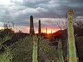
Roślinność na pustyni Sonora

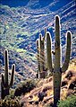
Roślinność na pustyni Sonora

Roślinność na pustyni Sonora
 In order to comply with the use and licensing terms of this image, the following text must must be included with the image when published in any medium, failure to do so constitutes a violation of the licensing terms and copyright infringement: © Tomas Castelazo, www.tomascastelazo.com / Wikimedia Commons, CC BY 3.0
Gleba pustyni Sonora
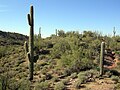
Pustynia w okolicach Wickenburga
Roślinność pustyni

Linki zewnętrzne
- Arizona-Sonora Desert Museum
- Timeline of the Sonoran desert
- An Overview of the Sonoran Desert, by William G. McGinnies. alic.arid.arizona.edu. [zarchiwizowane z tego adresu (2003-01-21)].
- The Sonoran Desert Naturalist
- Very short overview of Sonoran Desert Geology. dana.ucc.nau.edu. [zarchiwizowane z tego adresu (2006-02-25)].
- Sonoran Desert images at bioimages.vanderbilt.edu (slow modem version)
- Saguaro National Park Page
| Stolica | |
|---|---|
| Regiony i atrakcje | |
| Hrabstwa | |
| Wybrane miejscowości | |
| Symbole |
![]()
Media użyte na tej stronie
Autor: Uwe Dedering, Licencja: CC BY-SA 3.0
Relief location map of North America.
- Projection: Lambert azimuthal equal-area projection.
- Area of interest:
- N: 90.0° N
- S: 5.0° N
- W: -140.0° E
- E: -60.0° E
- Projection center:
- NS: 47.5° N
- WE: -100.0° E
- GMT projection: -JA-100/47.5/20.0c
- GMT region: -R-138.3726888474925/-3.941007863604182/2.441656573833029/50.63933645705661r
- GMT region for grdcut: -R-220.0/-4.0/20.0/90.0r
- Relief: SRTM30plus.
- Made with Natural Earth. Free vector and raster map data @ naturalearthdata.com.


Sonoran Desert outside Wickenburg, Arizona.

Desert landscape with saguaro cactii (Carnegiea gigantea) in Agua Fria National Monument, Arizona

Saguaro at sunset, Sonora Desert Museum, Arizona
Autor: Oryginalnym przesyłającym był Urban z francuskiej Wikipedii, Licencja: CC BY-SA 2.5
Carte de localisation du désert de Sonora (États-Unis / Mexique)
Source : et:Pilt:Sonora2.gif, Siim Sepp, 2004
Modifiée par l'utilisateur Urban, avec Paint, 2005

Autor: Tomascastelazo - Tomas Castelazo, Licencja: CC BY 3.0
Sonoran Desert, Mexico.
Autor: Uwe Dedering, Licencja: CC BY-SA 3.0
Relief location map of North America.
- Projection: Lambert azimuthal equal-area projection.
- Area of interest:
- N: 90.0° N
- S: 5.0° N
- W: -140.0° E
- E: -60.0° E
- Projection center:
- NS: 47.5° N
- WE: -100.0° E
- GMT projection: -JA-100/47.5/20.0c
- GMT region: -R-138.3726888474925/-3.941007863604182/2.441656573833029/50.63933645705661r
- GMT region for grdcut: -R-220.0/-4.0/20.0/90.0r
- Relief: SRTM30plus.
- Made with Natural Earth. Free vector and raster map data @ naturalearthdata.com.

In order to comply with the use and licensing terms of this image, the following text must must be included with the image when published in any medium, failure to do so constitutes a violation of the licensing terms and copyright infringement: © Tomas Castelazo, www.tomascastelazo.com / Wikimedia Commons, CC BY 3.0
Wysuszona ziemia na pustyni Sonora w Meksyku.