South Hams
| dystrykt niemetropolitalny | |
 | |
| Państwo | |
|---|---|
| Kraj | |
| Region | South West England |
| Hrabstwo | Devon |
| Siedziba | Totnes |
| Powierzchnia | 886,51 km² |
| Populacja (2011) • liczba ludności | 83 600 |
| • gęstość | 94 os./km² |
| Położenie na mapie hrabstwa Devon Contains Ordnance Survey data © Crown copyright and database right, CC BY-SA 3.0 | |
| Strona internetowa | |
| Portal | |
South Hams – dystrykt w hrabstwie Devon w Anglii.
Miasta
Inne miejscowości
Ashprington, Aveton Gifford, Avonwick, Berry Pomeroy, Bickleigh, Bigbury, Blackawton, Brixton, Brownston, Buckland, Buckland-Tout-Saints, Capton, Charleton, Chillington, Chivelstone, Churchstow, Cornwood, Cornworthy, Dartington, Dean Prior, Diptford, Dittisham, Down Thomas, East Allington, East Portlemouth, Ermington, Frogmore and Sherford, Hallsands, Halwell, Halwell and Moreleigh, Harberton, Harford, Holbeton, Holne, Hope Cove, Kingston, Kingswear, Littlehempston, Loddiswell, Malborough, Marldon, Newton and Noss, North Huish, Puslinch, Rattery, Ringmore, Roborough, Shaugh Prior, Sherford (miasto), Sherford (wieś), Slapton, South Brent, South Huish, South Milton, South Pool, Sparkwell, Staverton, Stoke Fleming, Stoke Gabriel, Stokenham, Strete, Thurlestone, Ugborough, Wembury, West Alvington, West Buckfastleigh, Woodleigh, Yealmpton.
Media użyte na tej stronie
Flag of England. Saint George's cross (a red cross on a white background), used as the Flag of England, the Italian city of Genoa and various other places.
Autor: Own Herby talk thyme, Licencja: CC BY-SA 4.0
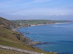
From Start Point looking towards Hallsands & Beesands in Devon.
Contains Ordnance Survey data © Crown copyright and database right, CC BY-SA 3.0
Map of Devon, UK with South Hams highlighted.
Equirectangular map projection on WGS 84 datum, with N/S stretched 150%


