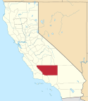
South Lake (hrabstwo Kern)
| ||
| Państwo | ||
| Stan | ||
| Wysokość | 880 m n.p.m. | |
| Nr kierunkowy | 760 | |
| Kod pocztowy | 93283 | |
| Portal | ||
South Lake – obszar niemunicypalny w hrabstwie Kern, w Kalifornii (Stany Zjednoczone), na wysokości 880 m. South Lake znajduje się wzdłuż południowego brzegu jeziora Isabella.
Według rejestru National Register of Historic Places osada istniała na tym obszarze już około roku 1499[1].
South Lake jest usytuowane przy drodze SR178.
Przypisy
- ↑ CALIFORNIA - Kern County (ang.). National Register of Historic Places. [dostęp 2019-05-09].
Linki zewnętrzne
Media użyte na tej stronie
Autor: NordNordWest, Licencja: CC BY 3.0
Location map of California, USA
Autor: Uwe Dedering, Licencja: CC BY-SA 3.0
Location map of the USA (without Hawaii and Alaska).
EquiDistantConicProjection:
Central parallel:
* N: 37.0° N
Central meridian:
* E: 96.0° W
Standard parallels:
* 1: 32.0° N
* 2: 42.0° N
Made with Natural Earth. Free vector and raster map data @ naturalearthdata.com.
Formulas for x and y:
x = 50.0 + 124.03149777329222 * ((1.9694462586094064-({{{2}}}* pi / 180))
      * sin(0.6010514667026994 * ({{{3}}} + 96) * pi / 180))
y = 50.0 + 1.6155950752393982 * 124.03149777329222 * 0.02613325650382181
      - 1.6155950752393982  * 124.03149777329222 *
     (1.3236744353715044  - (1.9694462586094064-({{{2}}}* pi / 180))
      * cos(0.6010514667026994 * ({{{3}}} + 96) * pi / 180))
The flag of Navassa Island is simply the United States flag. It does not have a "local" flag or "unofficial" flag; it is an uninhabited island. The version with a profile view was based on Flags of the World and as a fictional design has no status warranting a place on any Wiki. It was made up by a random person with no connection to the island, it has never flown on the island, and it has never received any sort of recognition or validation by any authority. The person quoted on that page has no authority to bestow a flag, "unofficial" or otherwise, on the island.
Flag of California. This version is designed to accurately depict the standard print of the bear as well as adhere to the official flag code regarding the size, position and proportion of the bear, the colors of the flag, and the position and size of the star.
Locator map showing Kern County — in central and southern California.
(c) David Jordan z angielskiej Wikipedii, CC BY-SA 3.0
en:CalTrans G9-2 guide sign describing South Lake, California.
This image has quality problems but documents the existence of South Lake. Will re-shoot this at some time in the future. If you get there first, overwrite this image with yours using the "Upload a newer version" option. About this image:
- Was captured using film or digital camera equipment.
- May lack artistic merit but documents the existence of the subject(s).
- May have had elements including colors, composition, gamma, exposure, or size adjusted using camera-, lens-, scanner-settings or by applying image editing software.
- May have had aberrations, flare, or reflections removed in order that the subject of the image is more clearly visible.
- Is intended to be representative of the view of the subject that would be perceived by a human eye.


