South Molton
 | |
| Państwo | |
|---|---|
| Kraj | |
| Hrabstwo | |
| Populacja (2002) • liczba ludności |
|
| Nr kierunkowy | 01271 |
| Kod pocztowy | EX36 |
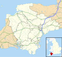
Położenie na mapie Devonu Contains Ordnance Survey data © Crown copyright and database right, CC BY-SA 3.0 | |
Położenie na mapie Wielkiej Brytanii (c) Karte: NordNordWest, Lizenz: Creative Commons by-sa-3.0 de | |
| Portal | |
South Molton - miasto w Wielkiej Brytanii, w Anglii w hrabstwie Devon położone nad rzeką Mole.
Historia
Pierwsze wzmianki pochodzą z roku 650, ośrodek był znany jako Dumnania[1]. Domesday Book nadmienia, że posiadał czterech księży. W średniowieczu niewielki ośrodek handlu wełną. Do XVIII wieku ośrodek wiejski, status gminy miejskiej uzyskał w roku 1835.
Dzisiejsze czasy
South Molton jest dziś ośrodkiem turystycznym o znaczeniu regionalnym, bazą wypadową w Exmoor i Dartmoor. Ośrodek handlowy o znaczeniu lokalnym.
Przypisy
- ↑ South Molton - little local history (ang.). [dostęp 2008-08-23]. [zarchiwizowane z tego adresu (9 maja 2008)].
Media użyte na tej stronie
(c) Karte: NordNordWest, Lizenz: Creative Commons by-sa-3.0 de
Location map of the United Kingdom
Flag of England. Saint George's cross (a red cross on a white background), used as the Flag of England, the Italian city of Genoa and various other places.
Contains Ordnance Survey data © Crown copyright and database right, CC BY-SA 3.0
Map of Devon, UK with the following information shown:
- Administrative borders
- Coastline, lakes and rivers
- Motorways and primary routes
- Urban areas
Equirectangular map projection on WGS 84 datum, with N/S stretched 150%
Geographic limits:
- West: 4.72W
- East: 2.86W
- North: 51.3N
- South: 50.16N
Autor: Jack1956, Licencja: CC BY-SA 4.0
The Guildhall in South Molton was constructed between 1739 to 1741. Behind it is the town's Pannier Market


