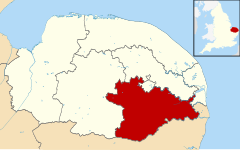
South Norfolk
| ||
| dystrykt niemetropolitalny | ||
(c) Ian Robertson, CC BY-SA 2.0 | ||
| Państwo | ||
|---|---|---|
| Kraj | ||
| Region | East of England | |
| Hrabstwo | Norfolk | |
| Siedziba | Long Stratton | |
| Powierzchnia | 907,7 km² | |
| Populacja (2011) • liczba ludności | 124 012 | |
| • gęstość | 140 os./km² | |
Położenie na mapie Norfolk | ||
| Strona internetowa | ||
| Portal | ||
South Norfolk – dystrykt w hrabstwie Norfolk w Anglii. W 2011 roku dystrykt liczył 124 012 mieszkańców[1].
Miasta
Inne miejscowości
Alburgh, Aldeby, Alpington, Arminghall, Ashby St Mary, Ashwellthorpe and Fundenhall, Aslacton, Barford, Barnham Broom, Bawburgh, Bedingham, Bergh Apton, Bixley, Bracon Ash, Bramerton, Brandon Parva, Bressingham, Brockdish, Brooke, Broome, Bunwell, Burgh St Peter, Burston and Shimpling, Burston, Caistor St. Edmund, Carleton Rode, Carleton St Peter, Chedgrave, Claxton, Colney, Costessey, Cringleford, Denton, Deopham, Dickleburgh, Dickleburgh and Rushall, Ditchingham, Dunston, Earsham, East Carleton, Easton, Ellingham, Fersfield, Flordon, Forncett, Forncett St Mary, Framingham Earl, Framingham Pigot, Geldeston, Gillingham, Gissing, Great Melton, Great Moulton, Haddiscoe, Hales, Hapton, Heckingham, Hedenham, Hellington, Hempnall, Hethel, Hethersett, Heywood, Howe, Intwood, Keswick, Ketteringham, Kimberley, Kirby Bedon, Kirby Cane, Kirstead, Kirstead Green, Langley with Hardley, Little Melton, Long Stratton, Marlingford and Colton, Morley Saint Botolph, Morley, Morningthorpe, Mulbarton, Mundham, Needham, Newton Flotman, Norton Subcourse, Poringland, Pulham Market, Pulham St Mary, Raveningham, Rockland St Mary, Roydon, Runhall, Saxlingham Nethergate, Scole, Seething, Shelfanger, Shelton and Hardwick, Shotesham, Sisland, Spooner Row, Starston, Stockton, Stoke Holy Cross, Surlingham, Swainsthorpe, Swardeston, Tacolneston, Tasburgh, Tharston and Hapton, Thelveton, Thorpe Abbotts, Thurlton, Thurton, Tibenham, Tivetshall St Margaret, Tivetshall St Mary, Toft Monks, Topcroft, Trowse Newton, Wacton, Wheatacre, Wicklewood, Winfarthing, Woodton, Wortwell, Wramplingham, Wreningham, Yelverton.
Przypisy
- ↑ Area: South Norfolk (Local Authority) (ang.). Neighbourhood Statistics (ONS). [dostęp 2016-05-06]. [zarchiwizowane z tego adresu (2016-10-10)].
Media użyte na tej stronie
Flag of England. Saint George's cross (a red cross on a white background), used as the Flag of England, the Italian city of Genoa and various other places.
Autor:
- Norfolk_UK_district_map_(blank).svg: Nilfanion, created using Ordnance Survey data
- derivative work: Renly (talk)
Map of Norfolk, with South Norfolk highlighted.
(c) Ian Robertson, CC BY-SA 2.0
South Norfolk Council Offices, Long Stratton


