South Northamptonshire
| dystrykt niemetropolitalny | |
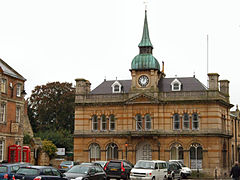
 Towcester | |
| Państwo | |
|---|---|
| Kraj | |
| Region | East Midlands |
| Hrabstwo | Northamptonshire |
| Siedziba | Towcester |
| Powierzchnia | 634 km² |
| Populacja (2011) • liczba ludności | 85 189 |
| • gęstość | 130 os./km² |
| Położenie na mapie Northamptonshire Contains Ordnance Survey data © Crown copyright and database right, CC BY-SA 3.0 | |
| Strona internetowa | |
| Portal | |
South Northamptonshire – dystrykt w hrabstwie Northamptonshire w Anglii. W 2011 roku dystrykt liczył 85 189 mieszkańców[1].
Miasta
Inne miejscowości
Abthorpe, Adstone, Alderton, Ashton, Aston le Walls, Aynho, Blakesley, Blisworth, Boddington, Bradden, Brafield-on-the-Green, Bugbrooke, Caldecote, Castle Ashby, Caswell, Chacombe, Chadstone, Charlton, Chipping Warden, Cogenhoe, Cold Higham, Cosgrove, Courteenhall, Croughton, Crowfield, Culworth, Dalscote, Deanshanger, Denton, Duncote, Eastcote, Edgcote, Evenley, Eydon, Falcutt, Farthinghoe, Furtho, Gayton, Grafton Regis, Greatworth, Greens Norton, Hackleton, Harpole, Hartwell, Helmdon, Hinton-in-the-Hedges, Horton, Kings Sutton, Kislingbury, Litchborough, Little Houghton, Lower Boddington, Maidford, Marston St. Lawrence, Middleton Cheney, Milton Malsor, Moreton Pinkney, Nether Heyford, Newbottle, Old Stratford, Overthorpe, Passenham, Pattishall, Paulerspury, Piddington, Potterspury, Preston Deanery, Pury End, Puxley, Quinton, Radstone, Roade, Rothersthorpe, Shutlanger, Silverstone, Slapton, Stoke Bruerne, Sulgrave, Syresham, Thenford, Thorpe Mandeville, Tiffield, Upper Boddington, Upper Heyford, Wappenham, Warkworth, Weedon Lois, Weston, Whiston, Whitfield, Whittlebury, Wicken, Wood Burcote, Woodend, Yardley Gobion, Yardley Hastings.
Przypisy
- ↑ Area: South Northamptonshire (Local Authority) (ang.). Neighbourhood Statistics (ONS). [dostęp 2016-04-29]. [zarchiwizowane z tego adresu (2016-10-06)].
Media użyte na tej stronie
Flag of England. Saint George's cross (a red cross on a white background), used as the Flag of England, the Italian city of Genoa and various other places.
Contains Ordnance Survey data © Crown copyright and database right, CC BY-SA 3.0
Map of Northamptonshire, UK with South Northamptonshire highlighted.
Equirectangular map projection on WGS 84 datum, with N/S stretched 160%The Old Town Hall, Towcester, Northamptonshire


