South Oxfordshire
| dystrykt niemetropolitalny | |
| Państwo | |
|---|---|
| Kraj | |
| Region | |
| Hrabstwo | |
| Siedziba | Crowmarsh Gifford |
| Powierzchnia | 678,54 km² |
| Populacja (2011) • liczba ludności |
|
| • gęstość | 200 os./km² |
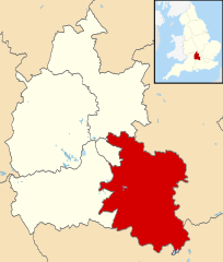
| Położenie na mapie Oxfordshire Contains Ordnance Survey data © Crown copyright and database right, CC BY-SA 3.0 | |
| Strona internetowa | |
| Portal | |
South Oxfordshire – dystrykt w hrabstwie Oxfordshire w Anglii.
Miasta
- Didcot
- Henley-on-Thames
- Thame
- Wallingford
- Watlington
Inne miejscowości
Adwell, Albury, Aston Rowant, Aston Tirrold, Aston Upthorpe, Baldon Row, Beckley and Stowood, Beckley, Benson, Berinsfield, Berrick Salome, Binfield Heath, Bix and Assendon, Bix, Brightwell Baldwin, Brightwell-cum-Sotwell, Britwell Salome, Burcot, Chalgrove, Checkendon, Chinnor, Chiselhampton, Cholsey, Christmas Common, Clifton Hampden, Crowmarsh Gifford, Cuddesdon, Culham, Cuxham, Dorchester on Thames, Drayton St. Leonard, Dunsden Green, Easington, East Hagbourne, Elsfield, Emmington, Ewelme, Forest Hill, Fulscot, Gallowstree Common, Garsington, Goring-on-Thames, Great Haseley, Great Holcombe, Great Milton, Harpsden, Henton, Highmoor, Holton, Horspath, Ipsden, Kidmore End, Kingston Blount, Lewknor, Little Baldon, Little Wittenham, Littlestoke, Long Wittenham, Lower Assendon, Mapledurham, Marsh Baldon, Middle Assendon, Moulsford, Nettlebed, Newington, Newnham Murren, Northend, North Moreton, North Stoke, Nuffield, Nuneham Courtenay, Oakley, Pishill, Postcombe, Preston Crowmarsh, Pyrton, Rotherfield Greys, Rotherfield Peppard, Sandford-on-Thames, Shiplake, Shirburn, Sonning Common, South Moreton, South Stoke, South Weston, Stadhampton, Stanton St. John, Stoke Row, Stoke Talmage, Stonor, Stonor Park, Sydenham, Tetsworth, Tiddington, Toot Baldon, Towersey, Trench Green, Warborough, Waterperry, Waterstock, West Hagbourne, Wheatley, Whitchurch Hill, Whitchurch-on-Thames, Winterbrook, Woodcote, Woodeaton.
Media użyte na tej stronie
Flag of England. Saint George's cross (a red cross on a white background), used as the Flag of England, the Italian city of Genoa and various other places.
The flag of the United Kingdom (3:5 version). This flag is the Union Flag in the 3:5 ratio exclusively used on land. At sea, the correct ratio is 1:2.
(c) Wurzeller z angielskojęzycznej Wikipedii, CC-BY-SA-3.0
en:Didcot, en:Oxfordshire, UK, grew up around the en:Great Western Railway. It is a rail junction and commuter town. This is the view of the power station from Platform 3 of Didcot Parkway station.
Picture taken by wurzeller on 10 May 2005 and hereby released under the terms of the GFDL.Contains Ordnance Survey data © Crown copyright and database right, CC BY-SA 3.0
Map of Oxfordshire, UK with South Oxfordshire highlighted.
Equirectangular map projection on WGS 84 datum, with N/S stretched 160%


