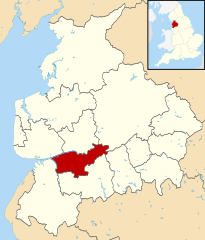
South Ribble
| dystrykt niemetropolitalny | |
(c) Ann Cook, CC BY-SA 2.0 Leyland | |
| Państwo | |
|---|---|
| Kraj | |
| Region | South West England |
| Hrabstwo | Lancashire |
| Siedziba | Leyland |
| Powierzchnia | 113 km² |
| Populacja (2016) • liczba ludności | 110 118[1] |
| • gęstość | 974 os./km² |
Położenie na mapie Lancashire | |
| Strona internetowa | |
| Portal | |
South Ribble – dystrykt w hrabstwie Lancashire w Anglii.
Miasta
Inne miejscowości
Bamber Bridge, Coupe Green, Farington, Farington Moss, Gregson Lane, Higher Walton, Hutton, Longton, Lostock Hall, Mellor Brook, Midge Hall, Much Hoole, New Longton, Samlesbury, Walmer Bridge, Walton-le-Dale, Whitestake.
Przypisy
- ↑ Population Estimates for UK, England and Wales, Scotland and Northern Ireland - Office for National Statistics, www.ons.gov.uk [dostęp 2017-10-21] (ang.).
Media użyte na tej stronie
Flag of England. Saint George's cross (a red cross on a white background), used as the Flag of England, the Italian city of Genoa and various other places.
Autor:
- Lancashire UK district map (blank).svg: Nilfanion, created using Ordnance Survey data
- derivative work: Renly (talk)
Map of Lancashire, with South Ribble highlighted.
(c) Ann Cook, CC BY-SA 2.0
Photograph of the Weavers' Cottages in Fox Lane, Leyland, Lancashire


