South Ronaldsay
 Fragment wybrzeża wyspy | |
| Kontynent | |
|---|---|
| Państwo | |
| Kraj | |
| Akwen | |
| Archipelag | |
| Powierzchnia | 49,80 km² |
| Najwyższy punkt | 118 m n.p.m. |
| Populacja (2013) • liczba ludności • gęstość |
|
Położenie na mapie Orkadów  Contains Ordnance Survey data © Crown copyright and database right, CC BY-SA 3.0 | |
Położenie na mapie Wielkiej Brytanii  | |
Położenie na mapie Szkocji | |
South Ronaldsay (w języku staronordyjskim Rognvaldsey oznacza wyspę Rognvalda[1]) – wyspa w archipelagu Orkadów w Szkocji. Liczy około 900 mieszkańców[2]. Główną wsią położoną na wyspie jest St Margaret's Hope, która połączona z największą wyspą archipelagu (Mainland) drogą A961 biegnącą przez Bariery Churchilla.
Geografia i geologia
Jest czwartą co do wielkości wyspą archipelagu Orkadów po Mainland, Hoy i Sanday.
Historia
Najstarsze ślady osadnictwa pochodzą z datowanego III tysiąclecia p.n.e.[3] Grobowca Orłów (ang. Tomb of the Eagles), gdzie znaleziono ponad 16 000 ludzkich i ponad 700 ptasich kości (głównie orłów Bielików).
Galeria
 (c) Bob Jones, CC BY-SA 2.0
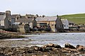
Widok na St Margaret's Hope

Kościół St Mary
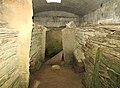
Wewnątrz Grobowca Orłów
Przypisy
- ↑ Orkney Placenames. [dostęp 2020-03-08]. (ang.).
- ↑ Scotland’s Census 2013 - Statistical Bulletin. National Record of Scotland, 2013-08-15. [dostęp 2020-03-08]. (ang.).
- ↑ Neil Wilson: Lonely Planet Scotland. Wyd. 5. Londyn: Lonely Planet, 2008, s. 413. ISBN 978-1-7410-459-01.
Bibliografia
Media użyte na tej stronie

.svg)
The flag of the United Kingdom (3:5 version). This flag is the Union Flag in the 3:5 ratio exclusively used on land. At sea, the correct ratio is 1:2.


Autor: John Haslam, Licencja: CC BY 2.0
South Ronaldsay is one of the Orkney Islands off the north coast of Scotland. It is linked to the Orkney Mainland by the Churchill Barriers, running via Burray, Glimps Holm and Lamb Holm.
Contains Ordnance Survey data © Crown copyright and database right, CC BY-SA 3.0
Relief map of the Orkney Islands (excluding Sule Stack and Sule Skerry), UK.
Equirectangular map projection on WGS 84 datum, with N/S stretched 180%
Geographic limits:
- West: 3.50W
- East: 2.35W
- North: 59.42N
- South: 58.60N
Autor: Alexrk2, Licencja: CC BY-SA 3.0
Location map of the United Kingdom

Autor: Beep boop beep, Licencja: CC BY-SA 4.0
This is a photo of listed building number

(c) Eric Gaba, NordNordWest, Uwe Dedering, CC BY-SA 3.0
Location map of Scotland, United Kingdom

Autor: D. Gordon E. Robertson, Licencja: CC BY-SA 4.0
Inside the Tomb of the Eagles, Isbister, Orkney, Scotland

(c) Bob Jones, CC BY-SA 2.0
St Margaret's Hope The buildings on the shore at St Margaret's Hope appear to have hardly changed in a century or more. Not a TV aerial in sight!