South Tyneside
| dystrykt metropolitalny | |||
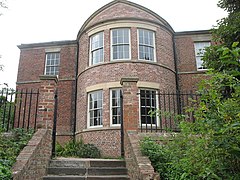
(c) Vin Mullen, CC BY-SA 2.0 Jarrow | |||
| |||
| Państwo | |||
|---|---|---|---|
| Kraj | |||
| Region | North East England | ||
| Hrabstwo | Tyne and Wear | ||
| Siedziba | South Shields | ||
| Powierzchnia | 64 km² | ||
| Populacja (2016) • liczba ludności | 149 418[1] | ||
| • gęstość | 2335 os./km² | ||
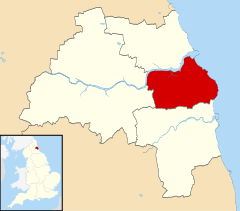
| Położenie na mapie Tyne and Wear Contains Ordnance Survey data © Crown copyright and database right, CC BY-SA 3.0 | |||
| Strona internetowa | |||
| Portal | |||
South Tyneside – dystrykt położony w hrabstwie metropolitarnym Tyne and Wear w północnej Anglii. Siedzibą dystryktu pozostaje miasto South Shields. Okręg graniczy z miastami Newcastle upon Tyne i Gateshead na zachodzie, Sunderland na południu i North Tyneside na północy. Na wschodzie naturalną granicę tworzy Morze Północne. Ważniejszymi miejscowościami w dystrykcie są Cleadon, Hebburn, Jarrow, The Boldons i Whitburn.
Gospodarka
Do niedawna na terenie South Tyneside dominował przemysł stoczniowy, górnictwo oraz przemysł chemiczny. Dystrykt znacznie podupadł w drugiej połowie XX wieku, kiedy to zamknięto większość kopalń, co doprowadziło do znacznego wzrostu bezrobocia. Obecnie w regionie można zauważyć pewne ożywienie gospodarcze, głównie za sprawą zabiegów władz, stawiających na rozwój sektora usług.
Miasta
Inne miejscowości
Biddick Hall, Brockley Whins, Cleadon, Marsden, The Boldons, West Harton i Whitburn.
Współpraca
Linki zewnętrzne
Przypisy
- ↑ Population Estimates for UK, England and Wales, Scotland and Northern Ireland - Office for National Statistics, www.ons.gov.uk [dostęp 2017-10-21] (ang.).
Media użyte na tej stronie
Flag of England. Saint George's cross (a red cross on a white background), used as the Flag of England, the Italian city of Genoa and various other places.
Autor:
- Ancla.gif: Silvestre
- Coat_of_arms_of_the_European_Security_and_Defence_College.svg: *Coat_of_arms_of_the_European_Union_Military_Staff.svg: Ssolbergj + authors of source files, including Sodacan
-
Escut_d'Estubeny.svg: Xavigivax (Taller de Heráldica y Vexilología in the Spanish Wikipedia
 )
) - derivative work: Ssolbergj (talk)
-
Coat_of_Arms_of_England_(-1340).svg: Sodacan
 Ta PNG grafika rastrowa została stworzona za pomocą Inkscape .
- Georgian_heraldry_motto.svg: Gaeser
- derivative work: Jza84 (talk)
The Coat of arms of South Tyneside Metropolitan Borough Council, the local government authority for the Metropolitan Borough of South Tyneside, in Tyne and Wear, England. The blazon is:
*ARMS: Vert an open Book proper bound and clasped between three Escutcheons Or a Chief wavy barry wavy of four Azure ans Argent.
*CREST: On a Wreath Argent and Vert issuant from a Mural Crown Or a demi-Lion Argent gorged with a Collar wavy Azure charged with a Bar wany Argent and holding between the paws an Anchor Azure roped proper.
Contains Ordnance Survey data © Crown copyright and database right, CC BY-SA 3.0
Map of Tyne and Wear, UK with South Tyneside highlighted.
Equirectangular map projection on WGS 84 datum, with N/S stretched 170%(c) Vin Mullen, CC BY-SA 2.0
Jarrow Hall, near to Jarrow, South Tyneside, Great Britain. Jarrow Hall viewed from Drewitt Park (Charlies Park) in Jarrow


