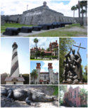
St. Augustine (Floryda)
 St. Augustine | |||
| |||
| Państwo | |||
|---|---|---|---|
| Stan | |||
| Burmistrz | Joseph L. Boles | ||
| Powierzchnia | 27,8 km² | ||
| Wysokość | 2 m n.p.m. | ||
| Populacja (2004) • liczba ludności • gęstość |
| ||
| Nr kierunkowy | 904 | ||
| Kod pocztowy | 32080, 32084, 32085, 32086, 32095, 32082, 32092 | ||
| Strona internetowa | |||
| Portal | |||
St. Augustine (hiszp. San Agustín) – miasto w Stanach Zjednoczonych, w stanie Floryda, w hrabstwie St. Johns. W 2004 roku miasto zamieszkiwało ok. 12 tysięcy mieszkańców. Zostało założone w roku 1565. Jest to najstarsza europejska osada w kontynentalnej części USA. Przez 235 lat była to polityczna i militarna stolica hiszpańskiej prowincji Floryda.
Historia
Wiosną 1513 hiszpański podróżnik, gubernator ówczesnego Portoryko - Juan Ponce de León przybył na ten teren jako pierwszy i objął go w imieniu hiszpańskiej korony. W miejscu przybycia odkrywcy znajduje się obecnie Fountain of Youth Archaeological Park[1].
Miasto, w dniu świętego Augustyna z Hippony tj. 28 sierpnia 1565, założył admirał Pedro Menéndez de Avilés, a nazwa miasta została nadana na cześć świętego. Król Filip II mianował Avilésa zarządcą Florydy.
Miasto atakowali Francuzi, ale dzięki huraganowi atak odparto. W 1586 zostało zaatakowane przez Brytyjczyków, którzy spustoszyli miasto.
W latach 1672-1695 Hiszpanie wybudowali wielką fortecę Castillo de San Marcos[2], a do budowy użyli skamieniałych muszli małż (był to pierwszy murowany fort w Ameryce).
W 1702 roku Anglicy splądrowali i spalili miasto, jednak nie zdobyli twierdzy.
W 1740 Anglicy ponownie uderzyli, ale nie zdobyli twierdzy. W 1763 Brytyjczycy weszli do miasta na podstawie traktatu pokojowego. Protestantyzm zastąpił katolicyzm.
W 1819 Hiszpania zrzekła się kolonii i oddała ją Stanom Zjednoczonym za pięć milionów dolarów.
W 1888 za ćwierć miliona dolarów został wybudowany hotel (jest siedzibą Flagler College[3]). W XIX w. wybudowano kościoły, hotele i domy milionerów.
W 1963 odbyła się w mieście manifestacja członków Ku Klux Klan. Tu po raz pierwszy został aresztowany Martin Luther King.
Znajduje się tu najstarsza w Ameryce szkoła. W mieście znajdują się 33 budowle, które wpisane są do Krajowego Rejestru Zabytków.
Miasta partnerskie
 Avilés, Hiszpania
 Cartagena, Kolumbia
 Minorka, Hiszpania
 Santo Domingo, Dominikana
Przypisy
- ↑ fountainofyouthflorida.com
- ↑ nps.gov
- ↑ flagler.edu. [dostęp 2010-02-25]. [zarchiwizowane z tego adresu (2010-02-19)].
Bibliografia
Media użyte na tej stronie
Autor: Uwe Dedering, Licencja: CC BY-SA 3.0
Location map of the USA (without Hawaii and Alaska).
EquiDistantConicProjection:
Central parallel:
* N: 37.0° N
Central meridian:
* E: 96.0° W
Standard parallels:
* 1: 32.0° N
* 2: 42.0° N
Made with Natural Earth. Free vector and raster map data @ naturalearthdata.com.
Formulas for x and y:
x = 50.0 + 124.03149777329222 * ((1.9694462586094064-({{{2}}}* pi / 180))
      * sin(0.6010514667026994 * ({{{3}}} + 96) * pi / 180))
y = 50.0 + 1.6155950752393982 * 124.03149777329222 * 0.02613325650382181
      - 1.6155950752393982  * 124.03149777329222 *
     (1.3236744353715044  - (1.9694462586094064-({{{2}}}* pi / 180))
      * cos(0.6010514667026994 * ({{{3}}} + 96) * pi / 180))
The flag of Navassa Island is simply the United States flag. It does not have a "local" flag or "unofficial" flag; it is an uninhabited island. The version with a profile view was based on Flags of the World and as a fictional design has no status warranting a place on any Wiki. It was made up by a random person with no connection to the island, it has never flown on the island, and it has never received any sort of recognition or validation by any authority. The person quoted on that page has no authority to bestow a flag, "unofficial" or otherwise, on the island.
Autor: Pedro A. Gracia Fajardo, escudo de Manual de Imagen Institucional de la Administración General del Estado, Licencja: CC0
Flaga Hiszpanii
The flag of the Dominican Republic has a centered white cross that extends to the edges. This emblem is similar to the flag design and shows a bible, a cross of gold and 6 Dominican flags. There are branches of olive and palm around the shield and above on the ribbon is the motto "Dios,Patria!, Libertad" ("God, Country, Freedom") and to amiable freedom. The blue is said to stand for liberty, red for the fire and blood of the independence struggle and the white cross symbolized that God has not forgotten his people. "Republica Dominicana". The Dominican flag was designed by Juan Pablo Duarte, father of the national Independence of Dominican Republic. The first dominican flag was sewn by a young lady named Concepción Bona, who lived across the street of El Baluarte, monument where the patriots gathered to fight for the independence, the night of February 27th, 1844. Concepción Bona was helped by her first cousin María de Jesús Pina.
Autor: Excel23, Licencja: CC BY-SA 3.0
Collection of photos I took around St. Augustine, Florida
(c) (Heralder), CC BY-SA 2.5
Coat of arms shown in the seal of Saint Augustine, Florida (USA)


