St. Paul’s
 | |
| Państwo | |
|---|---|
| Miejscowość | Londyn |
| Dzielnica | Katedra św. Pawła |
| Data otwarcia | 1900 |
| Liczba peronów | 2 |
| Central Line | |
| Poprzednia stacja | Chancery Lane |
| Następna stacja | Bank |
Położenie na mapie City of London  Contains Ordnance Survey data © Crown copyright and database right, CC BY-SA 3.0 | |
Położenie na mapie Wielkiej Brytanii  (c) Karte: NordNordWest, Lizenz: Creative Commons by-sa-3.0 de | |
Położenie na mapie Anglii  | |
Położenie na mapie Wielkiego Londynu  Contains Ordnance Survey data © Crown copyright and database right, CC BY-SA 3.0 | |
| Portal | |
St. Paul’s – stacja londyńskiego metra położona na trasie Central Line, pomiędzy stacjami Bank i Chancery Lane, w pierwszej strefie biletowej, w City of London.
Stacja znajduje się przy skrzyżowaniu ulic: Newgate Street, Cheapside i St Martin's le Grand, w sąsiedztwie katedry Świętego Pawła, od której zapożyczyła swoją nazwę. W sąsiedztwie stacji znajduje się również London Stock Exchange (giełda papierów wartościowych) i centrum handlowe One New Change.
Połączenia
Stacja obsługiwana jest przez autobusy linii 4, 8, 25, 56, 100, 172, 242 i 521.
Galeria

Zachodnie wejście z katedrą św. Pawła w tle, 2003
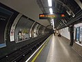
Platforma w kierunku wschodnim

Symbol stacji
| Linia główna | |
|---|---|
| Odgałęzienie West Ruislip | |
| Odgałęzienie Ealing Broadway | |
| Odgałęzienie Woodford | |
| Odgałęzienie Epping |
![]()
Media użyte na tej stronie
(c) Karte: NordNordWest, Lizenz: Creative Commons by-sa-3.0 de
Location map of the United Kingdom
Contains Ordnance Survey data © Crown copyright and database right, CC BY-SA 3.0
Map of Greater London, UK with the following information shown:
- Administrative borders
- Coastline, lakes and rivers
- Roads and railways
- Urban areas
The data includes both primary routes and railway lines.
Equirectangular map projection on WGS 84 datum, with N/S stretched 160%
Geographic limits:
- West: 0.57W
- East: 0.37E
- North: 51.72N
- South: 51.25N


Autor: Sunil060902, Licencja: CC BY-SA 3.0
St. Paul's tube station platform roundel

Autor: Sunil060902, Licencja: CC BY-SA 3.0
St. Paul's tube station eastbound platform undergoing refurbishment (July 2008), looking west.

Contains Ordnance Survey data © Crown copyright and database right, CC BY-SA 3.0
Blank map of the City of London, showing electoral wards.
Equirectangular map projection on WGS 84 datum, with N/S stretched 160%
Geographic limits:
- West: 0.12W
- East: 0.07W
- North: 51.525N
- South: 51.5N
Autor: Sunil060902, Licencja: CC BY-SA 3.0
St Paul's tube station main entrance, after recent refurbishment.