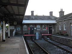
St Erth (stacja kolejowa)
 | |
| Państwo | |
|---|---|
| Kraj | |
| Miejscowość | |
| Data otwarcia | 1852 |
| Dane techniczne | |
| Liczba peronów | 3 |
| Liczba krawędzi peronowych | 3 |
| Kasy | czynne |
| Linie kolejowe | |
| |
Położenie na mapie Kornwalii Contains Ordnance Survey data © Crown copyright and database right, CC BY-SA 3.0 | |
Położenie na mapie Wielkiej Brytanii (c) Karte: NordNordWest, Lizenz: Creative Commons by-sa-3.0 de | |
| Portal | |
St Erth – węzeł kolejowy w miejscowości St Erth w Kornwalii, w Anglii na linii kolejowej Cornish Main Line z odgałęzieniem do St Ives (linia St Ives Bay Line. Linię do Sth Ives otwarto w 1877 roku. przyczyniła się ona znacznie do rozwoju turystyki na południowo-zachodnim wybrzeżu Kornwalii. Ma ona opinię jednej z najbardziej malowniczych linii kolejowych w Anglii[1].
Ruch pasażerski
W okresie od kwietnia 2020 do marca 2021 roku stacja obsłużyła 136 176 pasażerów[2]. Połączenie bezpośrednie do miejscowości Bristol, Exeter, Glasgow, Leeds, Londyn, Penzance, Plymouth, Swindon, St Ives.
Obsługa pasażerów
Stacja posiada kasy biletowe, informację kolejową, WC, przystanek autobusowy, postój taksówek. Na stacji znajduje się kawiarnia, która została wyróżniona w 2009 r. w konkursie na najlepsze kawiarnie dworcowe[3].
Zobacz też
Przypisy
- ↑ List of Scenic Rail Routes of Europe published in Thomas Cook European Timetables
- ↑ Estimates of station usage. Table 1410: Passenger entries, exits and interchanges by station (annual), Great Britain, Apr 2020 to Mar 2021, Office of Rail and Road Data Portal [dostęp 2022-10-25] [zarchiwizowane z adresu 2022-10-18] (ang.).
- ↑ Dixie Willis: Ten of the best railway cafes. The Guardian, 2009-05-12. [dostęp 2009-12-16]. (ang.).
Media użyte na tej stronie
Contains Ordnance Survey data © Crown copyright and database right, CC BY-SA 3.0
Map of Cornwall, UK with the following information shown:
- Administrative borders
- Coastline, lakes and rivers
- Roads and railways
- Urban areas
Equirectangular map projection on WGS 84 datum, with N/S stretched 150%
Geographic limits:
- West: 6.47W
- East: 4.00W
- North: 51.04N
- South: 49.83N
(c) Karte: NordNordWest, Lizenz: Creative Commons by-sa-3.0 de
Location map of the United Kingdom
Flag of England. Saint George's cross (a red cross on a white background), used as the Flag of England, the Italian city of Genoa and various other places.
Autor: Alexandra Lanes, Licencja: Copyrighted free use
Platform 3 and the station building at St Erth railway station. Platforms 1 and 2 (the main-line platforms) are off the left of the picture.


