Stacje polarne w Antarktyce


Stacje polarne w Antarktyce – placówki badawcze założone przez różne państwa w Antarktyce. Stacje te składają się głównie z kontenerów badawczych i mieszkalnych oraz własnego źródła energii (generatora prądu). Do stacji polarnych zalicza się wszystkie stacje działające w ramach Komitetu Naukowego Badań Antarktycznych (SCAR, ang. Scientific Committee on Antarctic Research). Stacje rozmieszczone są na samym kontynencie oraz na wyspach Antarktyki.
Obecnie istnieje 40 całorocznych i 41 stacji czynnych tylko latem, a ponadto placówki dające bardziej ograniczone możliwości bytowe i mniej wygód, klasyfikowane jako obozy i schronienia. Lista Rady Menadżerów Narodowych Programów Antarktycznych (COMNAP, ang. Council of Managers of National Antarctic Programs) wymienia wśród „głównych placówek” 14 obozów i 2 schronienia[1].
W sezonie zimowym półkuli południowej czerwiec – sierpień 2004 roku w stacjach polarnych przebywało 1028 osób personelu, a w sezonie letnim od grudnia 2004 do lutego 2005 – 3822 osób.
Państwa posiadające stacje polarne w Antarktyce
Stacje, i/lub okresowo czynne obozy, posiadają następujące państwa (2016)[1]:
| Państwo | Stacje i/lub obozy | Populacja | ||
|---|---|---|---|---|
| Całoroczne | Lato | Zimą | Max. | |
| 6 | 7 | 176 | 660 | |
| 3 | 1 | 62 | 200 | |
| 1 | 40 | |||
| 1 | 15 | 66 | ||
| 1 | 22 | |||
| 5 | 7 | 105 | 311 | |
| 2 | 2 | 31 | 148 | |
| 1 | 20 | |||
| 2 | 26 | |||
| 1 | 17 | |||
| 2¹ | 1 | 39 | 200 | |
| 3 | 98 | |||
| 2 | 1 | 40 | 65 | |
| 1 | 3 | 28 | 125 | |
| 2 | 38 | 123 | ||
| 1 | 4 | 15 | 147 | |
| 1 | 10 | 85 | ||
| 1 | 1 | 7 | 77 | |
| 1 | 28 | |||
| 1 | 12 | 40 | ||
| 1 | 10 | 80 | ||
| 5 | 7 | 88 | 375 | |
| 3 | 3 | 215 | 1399 | |
| 1 | 20 | |||
| 1 | 12 | 24 | ||
| 1 | 1 | 8 | 70 | |
| 2 | 3 | 44 | 223 | |
| 1¹ | 4 | 120 | ||
¹ jedna wspólna francusko-włoska
Alfabetyczny wykaz stacji całorocznych
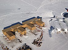
- Amundsen-Scott (Amundsen-Scott South Pole Station) – amerykańska; 89°59'51"S 139°16'22"
- Arctowski (Polska Stacja Antarktyczna im. Henryka Arctowskiego) – polska na Wyspie Króla Jerzego; 62°09'34"S 58°28'15"W
- Artigas (Base Artigas) – urugwajska na Wyspie Króla Jerzego; 62°11'04"S 58°54'09"W
- Arturo Prat (Base Naval Antartica Capitán Arturo Prat) – chilijska; 62°30'00"S 59°41'00"W
- Belgrano II (Base Antártica Belgrano II) – argentyńska; 77°52'29"S 34°37'37"W
- Bellingshausen (naucznaja stancyja Biellinsgauzien) – rosyjska na Wyspie Króla Jerzego; 62°11'47"S 58°57'39"W
- Bernardo O’Higgins (Base General Bernardo O’Higgins Riquelme) – chilijska; 63°19'15"S 57°54'01"W
- Bharati – indyjska; 69°24'28"S 76°11'14"E
- Carlini (Base Antártica Carlini, dawniej: Jubany) – argentyńska na Wyspie Króla Jerzego; 62°14'16"S 58°39'52"W
- Casey – australijska; 66°17'00"S 110°31'11"E
- Comandante Ferraz – brazylijska na Wyspie Króla Jerzego; 62°05'00"S 58°23'28"W
- Concordia – francusko-włoska; 72°06'06"S 123°23'43"E
- Davis – australijska; 68°34'38"S 77°58'21"E
- Dumont d’Urville – francuska; 66°39'46"S 140°00'05"E
- Eduardo Frei Montalva (Base Aera Presidente Eduardo Frei Montalva) – chilijska na Wyspie Króla Jerzego; 62°12'00"S 58°57'51"W
- Villa Las Estrellas – miejscowość stanowiąca część tej bazy
- Esperanza (Base Antártica Esperanza) – argentyńska; 63°23'42"S 56°59'46"W
- Halley – brytyjska; 75°34'54"S 26°32'28"W
- Jang Bogo – południowokoreańska; 74°37′0″S 164°12′5″E
- Julio Escudero (Base Profesor Julio Escudero) – chilijska; 62°12'04"S 58°57'45"W
- King Sejong – południowokoreańska na Wyspie Króla Jerzego; 62°13'24"S 58°47'21"W
- Maitri – indyjska; 70°45'57"S 11°44'09"E
- Marambio (Base Antártica Marambio) – argentyńska; 64°14'42"S 56°39'25"W
- Mawson – australijska; 67°36'17"S 62°52'15"E
- McMurdo (McMurdo Station) – amerykańska; 77°50'53"S 166°40'06"E
- Mirnyj (naucznaja stancyja Mirnyj) – rosyjska; 66°33'07"S 93°00'53"E
- Neumayer III (Georg von Neumayer) – niemiecka; 70°38'00"S 08°15'48"W
- Nowołazariewskaja (naucznaja stancyja Nowołazariewskaja) – rosyjska; 70°46'26"S 11°51'54"E
- Orcadas (Base Antártica Orcadas) – argentyńska na Orkadach Południowych; 60°44'20"S 44°44'17"W
- Palmer (Palmer Station) – amerykańska; 64°46'30"S 64°03'04"W
- Progress (naucznaja stancyja Progress) – rosyjska; 69°22'44"S 76°23'13"E
- Rothera – brytyjska; 67°34'10"S 68°07'12"W
- San Martin (Base Antártica San Martín) – argentyńska; 68°07'47"S 67°06'12"W
- SANAE IV (South African National Antarctic Expeditions IV) – południowoafrykańska; 71°40'25"S 02°49'44"W
- Scott Base – nowozelandzka; 77°51'00"S 166°45'46"E
- Syowa – japońska; 69°00'25"S 39°35'01"E
- Troll – norweska; 72°00'07"S 02°32'02"E
- Wielki Mur (Great Wall; Chang Cheng) – chińska; 62°12'59"S 58°57'44"W
- Wiernadski (Akademik Wernadśkyj) – ukraińska; 65°14'43"S 64°15'24"W
- Wostok (naucznaja stancyja Wostok) – rosyjska; 78°28'00"S 106°48'00"E
- Zhongshan – chińska; 69°22'16"S 76°23'13"E
Wybrane stacje czynne tylko w sezonie letnim

- Aboa – fińska; 73°03′S, 13°25′W
- Brown – argentyńska; 64°53′S, 62°53′W
- Dome Fuji – japońska (tymczasowo zamknięta); 77°19,02'S 39°42,20'E
- Gabriel de Castilla – hiszpańska; 62°58′S, 60°41′W
- Juan Carlos I – hiszpańska; 62°39′S, 60°23′W
- Kliment Ochridski – bułgarska na Wyspie Livingstona; 62°38'29"S 60°21'53"W
- Kohnen – niemiecka; 75°00'S 0°04'E
- Machu Picchu – peruwiańska; 62°05.4′S, 58°28.1′W
- Maldonado – ekwadorska; 62°26.96'S 59°44.54'W
- Mario Zucchelli – włoska; 74°42′S, 164°07′E
- Mendel – czeska; 63°48′S, 57°52′W
- Signy – brytyjska na Orkadach Południowych; 60°43'S 45°36'W
- Teniente Luis Carvajal Villaroel – chilijska na Wyspie Adelajdy; 67°46′S, 68°55′W
- Wasa – szwedzka; 73°03′S, 13°25′W
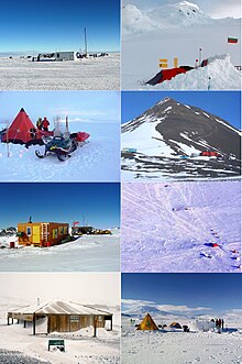
Obozy i schronienia
- australijskie: Wilkins Aerodrome
- amerykańskie: Marble Point Heliport, Odell Glacier Camp, Siple Dome
- brytyjskie: Fossil Bluff, Sky Blu
- chilijski: Lieutenant Rodolfo Marsh M. Aerodrome
- chiński: Taishan
- czeskie: Eco-Nelson
- ekwadorskie: Refugio Ecuador (Vicente)
- francuski: Cap Prud'homme
- norweskie: Tor
- włoskie: Browning Pass, Enigma Lake, Mid Point
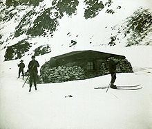
Ponadto na kontynencie i wyspach znajdują się mniejsze chatki (schronienia, z ang. „refugia”) używane w pracach terenowych, przynależne do większych stacji, takie jak Taturowa Chata na wyspie Króla Jerzego, będąca w dyspozycji personelu stacji im. Arctowskiego.
Stacje nieczynne i zlikwidowane
- amerykańskie: Byrd, Pieter Lenie, Siple
- amerykańsko-argentyńska: Ellsworth
- amerykańsko-nowozelandzka: Hallett
- australijska: Edgeworth David Base[2]
- australijsko-rumuńska: Law-Racovita-Negoita
- indyjska: Dakshin Gangotri
- japońska: Mizuho
- nowozelandzka: Vanda
- pakistańska: Jinnah
- polska: Dobrowolski
- radzieckie: Biegun niedostępności, Komsomolskaja, Pionierskaja, Sowietskaja
- szwedzka: Svea
- wschodnioniemiecka: Georg Forster
- Greenpeace: World Park Base
Przypisy
- ↑ a b c Main Antarctic Facilities operated by National Antarctic Programs in the Antarctic Treaty Area (South of 60° latitude South) (ang.). Council of Managers of National Antarctic Programs, 2016-07-27. [dostęp 2016-08-18].
- ↑ Images for Edgeworth David Base In The Bunger Hills [66°15' S, 100°36' E] (ang.). W: Australian Place Names (Gazetteer) [on-line]. Australian Antarctic Data Centre. [dostęp 2012-07-13].
Media użyte na tej stronie
Łatwo można dodać ramkę naokoło tej grafiki
Made by author of Xramp, first uploaded by Denelson83 as Flag of Ecuador.svg, modifications by Husunqu.
Flaga Finlandii
Autor: Pedro A. Gracia Fajardo, escudo de Manual de Imagen Institucional de la Administración General del Estado, Licencja: CC0
Flaga Hiszpanii
The Flag of India. The colours are saffron, white and green. The navy blue wheel in the center of the flag has a diameter approximately the width of the white band and is called Ashoka's Dharma Chakra, with 24 spokes (after Ashoka, the Great). Each spoke depicts one hour of the day, portraying the prevalence of righteousness all 24 hours of it.
Flag of New Zealand. Specification: http://www.mch.govt.nz/nzflag/description.html , quoting New Zealand Gazette, 27 June 1902.
The flag of Navassa Island is simply the United States flag. It does not have a "local" flag or "unofficial" flag; it is an uninhabited island. The version with a profile view was based on Flags of the World and as a fictional design has no status warranting a place on any Wiki. It was made up by a random person with no connection to the island, it has never flown on the island, and it has never received any sort of recognition or validation by any authority. The person quoted on that page has no authority to bestow a flag, "unofficial" or otherwise, on the island.
Autor: Acaro, Licencja: CC BY-SA 3.0
"Taturowa Chata", refugium of the Arctowski Station, King George Bay
Autor: Acaro, Licencja: CC BY-SA 3.0
Henryk Arctowski Polish Antarctic Station
Autor: Lyubomir Ivanov, Licencja: GPL
Bulgarian base St. Kliment Ohridski on Livingston Island, with Mount Friesland in the background.
- Viewpoint location: Swan Beach on Livingston Island, in the South Shetland Islands
- Viewpoint elevation: 3 meters
- View direction: east-southeast
- Camera: HP PhotoSmart C945 (V01.54)
Autor: Eli Duke, Licencja: CC BY-SA 2.0
A view of McMurdo Station, Antarctica.
Placówki badawcze w Antarktyce wg wykazu COMNAP z 2015 r. Czerwony: całoroczne stacje polarne; pomarańczowy: letnie stacje polarne; zielony: obozy; żółty: schronienia (refugia). Pogrubieniem wskazano największe stacje, zdolne pomieścić ponad 50 osób w okresie zimowym.
Buildings (Amundsen-Scott South Pole Station pictured) have to be built on stilts at the South Pole to prevent snow buildup. The ceremonial pole and flags can be seen in the background, slightly to the left of center, below the tracks behind the buildings. The actual geographic pole is a few more metres to the left. Flags and pole are more visible in en:Image:Amundsen-scott-south pole station 2006.jpg and en:Image:Ceremonial South Pole.jpg.
Autor: Apcbg, a derivative work of files from Wikimedia Commons, Licencja: CC BY-SA 3.0
A mosaic image of Antarctic field camps deriving from the following Wikimedia Commons images: File:Patriot Hills.jpg, license GFDL-self-no-disclaimers; File:Academia-6.JPG, license cc-by-sa-3.0, GFDL; File:Kg hut new view.jpg, license PD-user-w, English Wikipedia; File:Sky blu from the air.jpg, GFDL-user-en-with-disclaimers; File:Tenterebus.jpg, license PD-USGov-NSF; File:Scotts Hut Antarctica.jpg, license self-cc-by-3.0; File:CIMG2206.JPG, license PD-self; and File:Casanovas Peak.JPG, cc-by-sa-3.0, GFDL.


