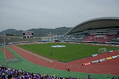
Stadion Hiroshima Big Arch
 Stadion Hiroshima Big Arch | |
| Państwo | |
|---|---|
| Data otwarcia | 1992 |
| Klub | |
| Pojemność stadionu | 50 000 |
Stadion Hiroshima Big Arch (Hiroshima Big Arch Stadium[1], jap. 広島ビッグアーチ[2]) – wielofunkcyjny stadion w Hiroszimie w Japonii. Został otwarty w 1992 roku. Może pomieścić 50 000 widzów. Swoje mecze rozgrywa na nim drużyna Sanfrecce Hiroszima[3]. Obiekt był główną areną Igrzysk Azjatyckich 1994[1]. Rozegrano na nim również część spotkań Pucharu Azji 1992 (w tym finał tego turnieju)[4], kobiecych Mistrzostw Świata U-20[5], a także po jednym spotkaniu turnieju Kirin Cup w latach 1994[6], 1995[7] i 2004[8].
Przypisy
- ↑ a b The 12th Asian Games Venue 2008 ↓.
- ↑ 広島ビッグアーチ (jap.). www.sanfrecce.co.jp. [dostęp 2011-06-30].
- ↑ Stadium Guide (ang.). www.sanfrecce.co.jp. [dostęp 2011-06-30].
- ↑ Hyung-Jin Yoon: Asian Nations Cup 1992 Final Tournament – Full Details (ang.). www.rsssf.com. [dostęp 2011-06-30].
- ↑ Japan 2012 venues and match schedule announced (ang.). www.fifa.com, 31 marca 2012. [dostęp 2012-09-22]. [zarchiwizowane z tego adresu (2012-08-21)].
- ↑ Neil Morrison: 1994 matches (ang.). www.rsssf.com. [dostęp 2011-06-30].
- ↑ Russell Gerrard: 1995 matches (ang.). www.rsssf.com. [dostęp 2011-06-30].
- ↑ Hamdan Saaid: Kirin Cup 2004 (ang.). www.rsssf.com. [dostęp 2011-06-30].
Bibliografia
- The 12th Asian Games Venue – Hiroshima Big Arch Stadium (ang.). W: The Official Website of the 16th Asian Games [on-line]. GAGOC, 2008-09-01 18:01:04. [dostęp 2016-03-22]. [zarchiwizowane z tego adresu (2016-03-08)].
Media użyte na tej stronie
Autor:
- Gfi-set01-stadium.png: gfi
- derivative work: Frédéric (talk)
icone pour terrain de sport
Hiroshima Bigarch Stadium.
Autor: OpenStreetMap contributors, Licencja: CC BY-SA 2.0
map of the urban area of Hiroshima City, Japan
Autor: Maximilian Dörrbecker (Chumwa), Licencja: CC BY-SA 3.0
Location map of Japan
Equirectangular projection.
Geographic limits to locate objects in the main map with the main islands:
- N: 45°51'37" N (45.86°N)
- S: 30°01'13" N (30.02°N)
- W: 128°14'24" E (128.24°E)
- E: 149°16'13" E (149.27°E)
Geographic limits to locate objects in the side map with the Ryukyu Islands:
- N: 39°32'25" N (39.54°N)
- S: 23°42'36" N (23.71°N)
- W: 110°25'49" E (110.43°E)
- E: 131°26'25" E (131.44°E)


