Stamford (Lincolnshire)
 | |||
| |||
| Państwo | |||
|---|---|---|---|
| Kraj | |||
| Hrabstwo | Lincolnshire | ||
| Dystrykt | South Kesteven | ||
| Populacja (2011) • liczba ludności | 19 701 | ||
| Nr kierunkowy | 01780 | ||
| Kod pocztowy | PE9 | ||
Położenie na mapie Lincolnshire Contains Ordnance Survey data © Crown copyright and database right, CC BY-SA 3.0 | |||
Położenie na mapie Wielkiej Brytanii (c) Karte: NordNordWest, Lizenz: Creative Commons by-sa-3.0 de | |||
| Portal | |||
Stamford – miasto w Anglii, w hrabstwie Lincolnshire, w dystrykcie South Kesteven. Leży 65 km na południe od miasta Lincoln i 130 km na północ od Londynu[1]. Według danych z 2011 roku miasto zamieszkiwało 19 701 osób [2][3][4][5]. Od końca XIII w. do XVII lub XVIII w. w Stamford znajdował się jeden z dwunastu krzyży Eleonory, upamiętniających miejsca postoju orszaku z ciałem królowej Anglii Eleonory kastylijskiej[6].
Przypisy
- ↑ Stamford na mapie (ang.). getamap.ordnancesurvey.co.uk. [dostęp 2010-10-06].
- ↑ All Saints - UK Census Data 2011, UK Census Data [dostęp 2018-09-25].
- ↑ St George's - UK Census Data 2011, UK Census Data [dostęp 2018-09-25].
- ↑ St Mary's - UK Census Data 2011, UK Census Data [dostęp 2018-09-25].
- ↑ Stamford St John's - UK Census Data 2011, UK Census Data [dostęp 2018-09-25].
- ↑ Ken Coles, John F H Smith: Queen Eleanor's Cross. Stamford and District Local History Society, 2014-01-08. [dostęp 2016-12-31]. [zarchiwizowane z tego adresu (2017-01-01)].
Media użyte na tej stronie
(c) Karte: NordNordWest, Lizenz: Creative Commons by-sa-3.0 de
Location map of the United Kingdom
Flag of England. Saint George's cross (a red cross on a white background), used as the Flag of England, the Italian city of Genoa and various other places.
Autor: Rich Farmbrough, Licencja: CC BY-SA 3.0
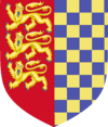
Arms of Stamford Town Council without supporters, crest or motto. Text from https://www.heraldry-wiki.com/heraldrywiki/wiki/Stamford : "The arms were officially recorded at the Visitation of 1634 for the former Borough of Stamford. The arms were described in 1634 "England, impaling Warrenne". The blue and gold chequers are those of the Earls Warenne, who held the Manor in the 13th century. The three gold lions on red, like the English Royal arms, were probably used as a token that Stamford was a royal borough. Tradition says that the town's fifteenth-century seal bears the arms of England (together with those of the Earls of Surrey, former lords of the town) as a reward for good services rendered by the men of Stamford at the Battle of Loosecoat Field (1469), but there is no supporting evidence for this."
Autor: SmileyRose, Licencja: CC BY-SA 3.0
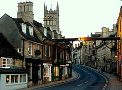
The view from Stamford Bridge looking up the hill towards the George Hotel.
Contains Ordnance Survey data © Crown copyright and database right, CC BY-SA 3.0
Map of Lincolnshire, UK with the following information shown:
- Administrative borders
- Coastline, lakes and rivers
- Roads and railways
- Urban areas
Equirectangular map projection on WGS 84 datum, with N/S stretched 165%
Geographic limits:
- West: 1.16W
- East: 0.39E
- North: 53.75N
- South: 52.62N


