Stargard Szczeciński Wąskotorowy
| ||
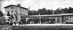
 Budynek stacyjny, 1903 r. | ||
| Państwo | ||
| Województwo | ||
| Miejscowość | Stargard | |
| Data otwarcia | 1895 | |
| Poprzednie nazwy | Stargard (Pommern) Ldb. | |
| Dane techniczne | ||
| Liczba peronów | 2 | |
| Liczba krawędzi peronowych | 3 | |
| Kasy | nieczynne | |
| Linie kolejowe | ||
| ||
Położenie na mapie Polski (c) Karte: NordNordWest, Lizenz: Creative Commons by-sa-3.0 de | ||
| Portal | ||
Stargard Szczeciński Wąskotorowy – nieczynna stacja kolejowa w Stargardzie, stacja początkowa Stargardzkiej Kolei Wąskotorowej.
Galeria
- Obecny wygląd stacji
| Stargard Szczeciński | ||
| Linia Stargard Szczeciński Wąskotorowy – Łobez Wąskotorowy (0,000 km) | ||
odległość: 5,09 km | ||
| Linia Stargard Szczeciński Wąskotorowy – Stargard Szczeciński (? km) | ||
odległość: ? km | ||
Media użyte na tej stronie
Poland adm location map.svg
(c) Karte: NordNordWest, Lizenz: Creative Commons by-sa-3.0 de
Location map of Poland
(c) Karte: NordNordWest, Lizenz: Creative Commons by-sa-3.0 de
Location map of Poland
West Pomeranian Voivodeship location map.svg
Autor: SANtosito, Licencja: CC BY-SA 4.0
Location map of West Pomeranian Voivodeship. Geographic limits of the map:
Autor: SANtosito, Licencja: CC BY-SA 4.0
Location map of West Pomeranian Voivodeship. Geographic limits of the map:
- N: 54.65 N
- S: 52.58 N
- W: 13.95 E
- E: 17.10 E
Powiat stargardzki location map.png
Autor:
Mapa powiatu stargardzkiego, Polska
Autor:
OpenStreetMap contributors
,
Licencja: CC BY-SA 2.0
Mapa powiatu stargardzkiego, Polska
BSicon KBHFl.svg
head station, track to the left
head station, track to the left
BSicon KBHFaq.svg
head station, track to the left
head station, track to the left
BSicon STRq.svg
Straight line aqross (according to naming convention, name + modifier)
Straight line aqross (according to naming convention, name + modifier)
BSicon KBHFr.svg
head station, track to the right
head station, track to the right
BSicon KBHFeq.svg
head station, track to the right
head station, track to the right
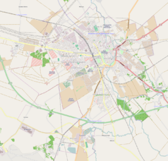
Stargard location map.png
Autor: OpenStreetMap contributors, Licencja: ODbL
OpenStreetMap location map of Stargard Szczeciński, Poland
Autor: OpenStreetMap contributors, Licencja: ODbL
OpenStreetMap location map of Stargard Szczeciński, Poland
- top = 53.366
- bottom = 53.2871
- left = 14.9555
- right = 15.0932
Stargard Wąsk. stacja 1903.JPG
Stacja w Stargardzie w 1903r.
Stacja w Stargardzie w 1903r.
Stargard Szczec dworzec waskotorowy (1).jpg
Autor: Kapitel, Licencja: CC BY-SA 4.0
Dawny dworzec wąskotorowy w Stargardzie Szczecińskim
Autor: Kapitel, Licencja: CC BY-SA 4.0
Dawny dworzec wąskotorowy w Stargardzie Szczecińskim
Stargard Szczec dworzec waskotorowy (2).jpg
Autor: Kapitel, Licencja: CC BY-SA 4.0
Dawny dworzec wąskotorowy w Stargardzie Szczecińskim
Autor: Kapitel, Licencja: CC BY-SA 4.0
Dawny dworzec wąskotorowy w Stargardzie Szczecińskim


