Stettlen
 | |||
| |||
| Państwo | |||
|---|---|---|---|
| Kanton | |||
| Okręg | |||
| SFOS | 0358 | ||
| Powierzchnia | 3,50 km² | ||
| Wysokość | 570 m n.p.m. | ||
| Populacja (31 grudnia 2020) • liczba ludności • gęstość |
| ||
| Nr kierunkowy | 031 | ||
| Kod pocztowy | 3066 | ||
| Tablice rejestracyjne | BE | ||
 | |||
Położenie na mapie Szwajcarii  (c) Karte: NordNordWest, Lizenz: Creative Commons by-sa-3.0 de | |||
| Strona internetowa | |||
Stettlen – gmina (niem. Einwohnergemeinde) w Szwajcarii, w kantonie Berno, w regionie administracyjnym Bern-Mittelland, w okręgu Bern-Mittelland.
Demografia
W Stettlen mieszkają 3 162 osoby. W 2020 roku 15,9% populacji gminy stanowiły osoby urodzone poza Szwajcarią[1].
Transport
Przez teren gminy przebiega droga główna nr 234.
Przypisy
- ↑ a b Bundesamt für Statistik, Ständige Wohnbevölkerung nach Staatsangehörigkeitskategorie, Geschlecht und Gemeinde, definitive Jahresergebnisse, 2020 - 2020 | Tabelle, Bundesamt für Statistik, 1 września 2021 [dostęp 2022-05-16] (niem.).
Okręg Bern-Mittelland (Verwaltungskreis Bern-Mittelland)
Siedziba okręgu: Ostermundigen

Media użyte na tej stronie
Switzerland adm location map.svg
(c) Karte: NordNordWest, Lizenz: Creative Commons by-sa-3.0 de
Location map of Switzerland
(c) Karte: NordNordWest, Lizenz: Creative Commons by-sa-3.0 de
Location map of Switzerland


Stettlen-coat of arms.svg
Autor: Aliman5040, Licencja: CC-BY-SA-3.0
coat of arms municipality of Stettlen, Switzerland)
Autor: Aliman5040, Licencja: CC-BY-SA-3.0
coat of arms municipality of Stettlen, Switzerland)

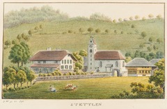
CH-NB - Stettlen - Collection Gugelmann - GS-GUGE-WEIBEL-D-130b.tif
Stettlen; Pfarrhaus und Kirche.; Stettlen; Umrissradierung, koloriert
Stettlen; Pfarrhaus und Kirche.; Stettlen; Umrissradierung, koloriert
Ostermundigen-coat of arms.svg
Autor: Aliman5040, Licencja: CC-BY-SA-3.0
coat of arms municipality of Ostermundigen, Switzerland)
Autor: Aliman5040, Licencja: CC-BY-SA-3.0
coat of arms municipality of Ostermundigen, Switzerland)