Steyr (miasto)
 | |||
| |||
| Państwo | |||
|---|---|---|---|
| Kraj związkowy | |||
| Burmistrz | Gerald Hackl | ||
| Powierzchnia | 26,54 km² | ||
| Wysokość | 310 m n.p.m. | ||
| Populacja (1 stycznia 2015) • liczba ludności • gęstość |
| ||
| Nr kierunkowy | 07252 | ||
| Kod pocztowy | 4400, 4402, 4403, 4405, 4407, 4451 | ||
| Tablice rejestracyjne | SR | ||
| Strona internetowa | |||
Steyr – miasto statutarne w północnej Austrii, w kraju związkowym Górna Austria, siedziba powiatu Steyr-Land do którego jednak nie należy. Leży u ujścia rzeki Steyr do Anizy (dorzecze Dunaju). Liczy 38,3 tys. mieszkańców.
Miasto Steyr było pierwszym w Europie miastem posiadającym elektryczne oświetlenie uliczne. Latarnie z lampami łukowymi zostały wyprodukowane na miejscu, w dziale produkcji cywilnej zakładów Josefa Werndla[1].
Urodziła się tutaj Barbara Haas, austriacka tenisistka.
W mieście rozwinął się przemysł zbrojeniowy, środków transportu, maszynowy, metalowy, spożywczy oraz drzewny[2].
Miasta partnerskie
 Betlejem, Autonomia Palestyńska
 Eisenerz, Styria
 Kettering, Stany Zjednoczone
 Plauen, Niemcy
 San Benedetto del Tronto, Włochy
Przypisy
- ↑ Lampy łukowe
- ↑ Steyr, [w:] Encyklopedia PWN [online] [dostęp 2021-08-17].
Media użyte na tej stronie
Autor: Lencer, Licencja: CC BY-SA 3.0
Location map of Austria
Equirectangular projection, N/S stretching 150 %. Geographic limits of the map:
- N: 49.2° N
- S: 46.3° N
- W: 9.4° E
- E: 17.2° E
The flag of Navassa Island is simply the United States flag. It does not have a "local" flag or "unofficial" flag; it is an uninhabited island. The version with a profile view was based on Flags of the World and as a fictional design has no status warranting a place on any Wiki. It was made up by a random person with no connection to the island, it has never flown on the island, and it has never received any sort of recognition or validation by any authority. The person quoted on that page has no authority to bestow a flag, "unofficial" or otherwise, on the island.
Autor: Rosso Robot, Licencja: CC BY-SA 3.0
Location map of Upper Austria
Equirectangular projection. Geographic limits of the map:
- N: 48.78063° N
- S: 47.44388° N
- W: 12.73041° E
- E: 15.00183° E
Autor: Herbert Ortner, Vienna, Austria, Licencja: CC BY 2.5
Quayside at river Enns in Steyr
Autor: Christoph Waghubinger (Lewenstein), Licencja: CC BY-SA 3.0 at
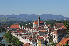
Blick vom Tabor auf die Steyrer Altstadt


