Stockelsdorf
| gmina | |||||
(c) Genet, CC-BY-SA-3.0 | |||||
| |||||
| Państwo | |||||
|---|---|---|---|---|---|
| Kraj związkowy | |||||
| Powiat | Ostholstein | ||||
| Kod statystyczny | 01 0 55 040 | ||||
| Powierzchnia | 56,70 km² | ||||
| Wysokość | 18 m n.p.m. | ||||
| Populacja (31.12.2008) • liczba ludności | 16 641 | ||||
| • gęstość | 293 os./km² | ||||
| Numer kierunkowy | 04504, 04505, 04506, 0451 | ||||
| Kod pocztowy | 23612, 23617 | ||||
| Tablice rejestracyjne | OH | ||||
Adres urzędu: Ahrensböker Straße 723617 Stockelsdorf | |||||
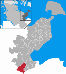
Położenie na mapie powiatu | |||||
| 53°53′N 10°39′E/53,883333 10,650000 | |||||
| Strona internetowa | |||||
| Portal | |||||
Stockelsdorf - gmina w północnych Niemczech w kraju związkowym Szlezwik-Holsztyn, w powiecie Ostholstein. Liczy ok. 16,6 tys. mieszkańców.
Media użyte na tej stronie
Flagge Stockelsdorf.png
Flagge Stockelsdorf
Flagge Stockelsdorf
Stockelsdorf Wappen.png
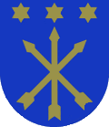
Coat of arms of the municipality Stockelsdorf in Schleswig-Holstein, Germany.
Coat of arms of the municipality Stockelsdorf in Schleswig-Holstein, Germany.
Wappen Kreis Ostholstein.png
Coat Of Arms of the district Ostholstein in Schleswig-Holstein, Germany.
Coat Of Arms of the district Ostholstein in Schleswig-Holstein, Germany.
Stockelsdorf in OH.png
Autor: The map was created by ClausG., Licencja: CC-BY-SA-3.0
This map shows the area of the Gemeinde (municipality) Stockelsdorf in the Kreis (district) Ostholstein, Schleswig-Holstein, Germany.
Autor: The map was created by ClausG., Licencja: CC-BY-SA-3.0
This map shows the area of the Gemeinde (municipality) Stockelsdorf in the Kreis (district) Ostholstein, Schleswig-Holstein, Germany.


