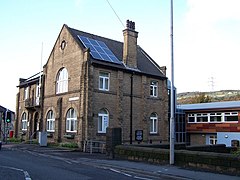
Stocksbridge
(c) Terry Robinson, CC BY-SA 2.0 | |
| Państwo | |
|---|---|
| Kraj | |
| Region | Yorkshire and The Humber |
| Hrabstwo ceremonialne | |
| Unitary authority | |
| Populacja (2011) • liczba ludności |
|
| Nr kierunkowy | 0114 |
| Kod pocztowy | S36 |
Położenie na mapie Sheffield Contains Ordnance Survey data © Crown copyright and database right, CC BY-SA 3.0 | |
Położenie na mapie Wielkiej Brytanii (c) Karte: NordNordWest, Lizenz: Creative Commons by-sa-3.0 de | |
Położenie na mapie South Yorkshire Contains Ordnance Survey data © Crown copyright and database right, CC BY-SA 3.0 | |
| Strona internetowa | |
| Portal | |
Stocksbridge – miasto i civil parish w Wielkiej Brytanii, w Anglii, w hrabstwie South Yorkshire, w dystrykcie (unitary authority) Sheffield[1]. W 2011 roku civil parish liczyła 13 455 mieszkańców[2].
W mieście ma swą siedzibę klub piłkarski Stocksbridge Park Steels F.C.
Przypisy
- ↑ Ordnance Survey linked data
- ↑ Neighbourhood Statistics. [dostęp 2015-09-26]. [zarchiwizowane z tego adresu (2015-09-28)].
Media użyte na tej stronie
(c) Karte: NordNordWest, Lizenz: Creative Commons by-sa-3.0 de
Location map of the United Kingdom
Contains Ordnance Survey data © Crown copyright and database right, CC BY-SA 3.0
Map of South Yorkshire, UK with the following information shown:
- Administrative borders
- Coastline, lakes and rivers
- Roads and railways
- Urban areas
Equirectangular map projection on WGS 84 datum, with N/S stretched 165%
Geographic limits:
- West: 1.84W
- East: 0.85W
- North: 53.67N
- South: 53.26N
Flag of England. Saint George's cross (a red cross on a white background), used as the Flag of England, the Italian city of Genoa and various other places.
Contains Ordnance Survey data © Crown copyright and database right, CC BY-SA 3.0
Map of Sheffield, South Yorkshire, UK with electoral wards shown.
Equirectangular map projection on WGS 84 datum, with N/S stretched 165%
Geographic limits:
- West: 1.82W
- East: 1.30W
- North: 53.51N
- South: 53.29N
(c) Terry Robinson, CC BY-SA 2.0
Stocksbridge Town Hall. A nice building ... but, in my opinion spoiled by the unsympathetic extension and (ugh!) the solar panels. Let's hope they applied for permission for these ... and got it! 1054934


