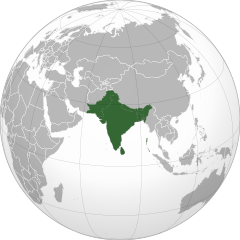
Subkontynent indyjski
| Ten artykuł od 2022-07 wymaga zweryfikowania podanych informacji. |
 Subkontynent indyjski | |
| Państwo | |
|---|---|
| Miejscowości | |
| 22,20775°N 76,97021°E/22,207750 76,970210 | |
Subkontynent indyjski – obszar w Azji, który obejmuje Półwysep Indyjski z Niziną Hindustańską i Cejlonem.

Zobacz też
Media użyte na tej stronie
The Flag of India. The colours are saffron, white and green. The navy blue wheel in the center of the flag has a diameter approximately the width of the white band and is called Ashoka's Dharma Chakra, with 24 spokes (after Ashoka, the Great). Each spoke depicts one hour of the day, portraying the prevalence of righteousness all 24 hours of it.
Autor: Jeet Dev (talk), Licencja: CC BY-SA 3.0
Grey-green orthographic projection focused on the Indian Subcontinent, where all countries part of said Indian Subcontinent are highlighted dark green to provide the viewer with a visual representation of where the Indian Subcontinent is and what countries are part of it.
Autor: Uwe Dedering, Licencja: CC BY-SA 3.0
Location map of India.
Equirectangular projection. Stretched by 106.0%. Geographic limits of the map:
- N: 37.5° N
- S: 5.0° N
- W: 67.0° E
- E: 99.0° E


