Tacloban
| Państwo | |
|---|---|
| Region | |
| Burmistrz | Alfred S. Romualdez |
| Powierzchnia | 201,72 km² |
| Wysokość | 21 m n.p.m. |
| Populacja • liczba ludności |
|
| Nr kierunkowy | 053 |
| Kod pocztowy | 6500 |
| Strona internetowa | |
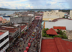
Tacloban – miasto portowe na Filipinach, w regionie Wschodnie Visayas, na wyspie Leyte. W 2010 roku miasto to zamieszkiwało 221 174 osób.
8 listopada 2013 roku miasto zostało poważnie zniszczone przez tajfun Haiyan. Zniszczenia objęły ok. 80 procent miasta, zostało ono de facto odcięte od świata[1].
W mieście rozwinął się przemysł spożywczy oraz odzieżowy[2].
Przypisy
- ↑ aw, dt, PAP: 10 tys. ofiar tajfunu na Filipinach. "Wszędzie szukamy jedzenia" (pol.). gazeta.pl, 10 listopada 2013. [dostęp 2014-05-29].
- ↑ Tacloban, [w:] Encyklopedia PWN [online] [dostęp 2021-08-21].
Media użyte na tej stronie
(c) Russell Watkins/Department for International Development, CC BY 2.0
A church on the outskirts of Tacloban is one of the few buildings to remain unscathed after Typhoon Haiyan devastated the city on 8 November 2013.
Two and a half weeks on from the disaster the main roads have been cleared and aid is getting through but, many people remain in need of assistance. The UK is providing £55m in humanitarian aid, in the form of shelter kits, food, medicine and water purification tablets, as well as Royal Navy ships and Royal Air Force planes to help distribute the aid to remote areas.Autor: NordNordWest, Licencja: CC BY 3.0
Location map of the Philippines
Autor: Mike Gonzalez (TheCoffee), Licencja: CC-BY-SA-3.0
Map of Leyte showing the location of Tacloban City


