Tanegashima
 Zdjęcie satelitarne | |
| Kontynent | |
|---|---|
| Państwo | |
| Akwen | |
| Archipelag | Wyspy Ōsumi |
| Powierzchnia | 444.99 km² |
| Długość linii brzegowej | 186 |
| Najwyższy punkt | 282 m n.p.m. |
| Populacja • liczba ludności |
|
Położenie na mapie Japonii  | |
Tanegashima (jap. 種子島 Tane-ga-shima) – japońska wyspa w archipelagu Ōsumi będącego częścią Wysp Satsunan w łańcuchu Riukiu. Administracyjnie należy do prefektury Kagoshima.
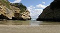
Tanegashima zajmuje powierzchnię 445 km². Jest wyspą wulkaniczną o długości 57 km i szerokości od 5 do 10 km. Linię brzegową o długości 186 km stanowią skaliste wybrzeża i piaszczyste plaże. Na wyspie panuje klimat subtropikalny.
Liczba ludności wynosi ok. 33 tys. Największym miastem jest Nishinoomote. Wyspa posiada port lotniczy oraz połączenia promowe.
W południowej części wyspy znajduje się Centrum Lotów Kosmicznych Tanegashima.
Galeria

Położenie wyspy
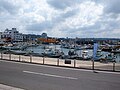
Port w Nishinoomote

Kosmodrom Tanegashima
 (c) Y.Kowashi, CC BY 3.0
Wybrzeże wyspy

Wybrzeże wyspy

Bibliografia
- tanegashimajapan.com
- Strona prefektury Kagoshima. pref.kagoshima.jp. [zarchiwizowane z tego adresu (2019-01-16)].
- alljapantours.com
Media użyte na tej stronie


Autor: Alexrk2, Licencja: CC BY-SA 3.0
Natural Location map of Japan
Equirectangular projection.
Geographic limits to locate objects in the main map with the main islands:
- N: 45°51'37" N (45.86°N)
- S: 30°01'13" N (30.02°N)
- W: 128°14'24" E (128.24°E)
- E: 149°16'13" E (149.27°E)
Geographic limits to locate objects in the side map with the Ryukyu Islands:
- N: 39°32'25" N (39.54°N)
- S: 23°42'36" N (23.71°N)
- W: 110°25'49" E (110.43°E)
- E: 131°26'25" E (131.44°E)


Tanega-shima Island, Kagoshima prefecture, Japan.
_Mission_(12812960063).jpg)
A Japanese H-IIA rocket carrying the NASA-Japan Aerospace Exploration Agency (JAXA), Global Precipitation Measurement (GPM) Core Observatory is seen as it rolls out to launch pad 1 of the Tanegashima Space Center, Thursday, Feb. 27, 2014, Tanegashima, Japan. Once launched, the GPM spacecraft will collect information that unifies data from an international network of existing and future satellites to map global rainfall and snowfall every three hours. Photo Credit: (NASA/Bill Ingalls)