Tanglang La
| Ten artykuł od 2022-07 wymaga zweryfikowania podanych informacji. |
 | |
| Państwo | |
|---|---|
| Wysokość | 5359 m n.p.m. |
| Pasmo | |
| 33°30′27″N 77°46′12″E/33,507500 77,770000 | |
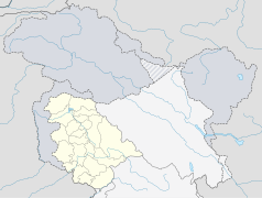
Taglang La – przełęcz górska w Himalajach o wysokości 5359 m. Leży w Ladakhu, w Indiach. Jest to jedna z najwyższych przejezdnych przełęczy świata. Prowadzi przez nią droga z Leh do Manali.
Linki zewnętrzne
- Tanglang La. neoncarrot.co.uk. [zarchiwizowane z tego adresu (2010-06-14)].
Media użyte na tej stronie
The Flag of India. The colours are saffron, white and green. The navy blue wheel in the center of the flag has a diameter approximately the width of the white band and is called Ashoka's Dharma Chakra, with 24 spokes (after Ashoka, the Great). Each spoke depicts one hour of the day, portraying the prevalence of righteousness all 24 hours of it.
Autor: Uwe Dedering, Licencja: CC BY-SA 3.0
Location map of India.
Equirectangular projection. Stretched by 106.0%. Geographic limits of the map:
- N: 37.5° N
- S: 5.0° N
- W: 67.0° E
- E: 99.0° E
Autor:
- India_Jammu_and_Kashmir_location_map.svg: NordNordWest
- derivative work: Avoided blue (talk)
Location map of Jammu and Kashmir, India. De facto situation.
oriented mountain pass symbol : n ne e se
Autor: Autor nie został podany w rozpoznawalny automatycznie sposób. Założono, że to Deeptrivia (w oparciu o szablon praw autorskich)., Licencja: CC-BY-SA-3.0
Taglang La, a Himalayan mountain pass in the Ladakh region of Jammu and Kashmir, northern India. It is one of the highest motorable passes in the world.


