Tauplitzalm
| ||
 | ||
| Państwo | ||
| Kraj związkowy | ||
| Wysokość | 1600 m n.p.m. | |
Położenie na mapie Styrii  | ||
Położenie na mapie Austrii  | ||
| Strona internetowa | ||
Tauplitzalm – płaskowyż w regionie Salzkammergut położony na wysokości od 1600 m do 2000 m n.p.m. w paśmie górskim Totes Gebirge. Leży w powiecie Liezen w kraju związkowym Styria. Na płaskowyż prowadzi wyciąg krzesełkowy z Tauplitz. Tauplitzalm jest także połączone drogą Tauplitzalm Alpenstraße z Bad Mitterndorf.
Jeziora na Tauplitzalm

Großsee

Krallersee
Märchensee

Steirersee
Linki zewnętrzne
- OIficjalna strona (niem.)
Media użyte na tej stronie
Austria location map.svg
Autor: Lencer, Licencja: CC BY-SA 3.0
Location map of Austria
Autor: Lencer, Licencja: CC BY-SA 3.0
Location map of Austria
Equirectangular projection, N/S stretching 150 %. Geographic limits of the map:
- N: 49.2° N
- S: 46.3° N
- W: 9.4° E
- E: 17.2° E


Austria Styria location map.svg
Autor: Rosso Robot, versions later 2013-12: NordNordWest, Licencja: CC BY-SA 3.0
Location map of Styria
Autor: Rosso Robot, versions later 2013-12: NordNordWest, Licencja: CC BY-SA 3.0
Location map of Styria
Equirectangular projection. Geographic limits of the map:
- N: 47.8849333° N
- S: 46.57305° N
- W: 13.5085305° E
- E: 16.2235138° E

Bad Mitterndorf - Märchensee.JPG
Autor: Bwag, Licencja: CC BY-SA 4.0
The Märchensee on the Tauplitzalm in Bad Mitterndorf, Styria, Austria.
Autor: Bwag, Licencja: CC BY-SA 4.0
The Märchensee on the Tauplitzalm in Bad Mitterndorf, Styria, Austria.
Bad Mitterndorf - Tauplitzalm.JPG
Autor: Bwag, Licencja: CC BY-SA 4.0
South view of the Tauplitzalm in Bad Mitterndorf, Styria, Austria.
Autor: Bwag, Licencja: CC BY-SA 4.0
South view of the Tauplitzalm in Bad Mitterndorf, Styria, Austria.

Bad Mitterndorf - Krallersee.JPG
Autor: Bwag, Licencja: CC BY-SA 4.0
The Krallersee on the Tauplitzalm in Bad Mitterndorf, Styria, Austria.
Autor: Bwag, Licencja: CC BY-SA 4.0
The Krallersee on the Tauplitzalm in Bad Mitterndorf, Styria, Austria.

Bad Mitterndorf - Großsee.JPG
Autor: Bwag, Licencja: CC BY-SA 4.0
The Großssee on the Tauplitzalm in Bad Mitterndorf, Styria, Austria.
Autor: Bwag, Licencja: CC BY-SA 4.0
The Großssee on the Tauplitzalm in Bad Mitterndorf, Styria, Austria.
.JPG)
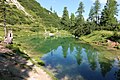
Bad Mitterndorf - Steirersee (a).JPG
Autor: Bwag, Licencja: CC BY-SA 4.0
The Steirersee on the Tauplitzalm in Bad Mitterndorf, Styria, Austria.
Autor: Bwag, Licencja: CC BY-SA 4.0
The Steirersee on the Tauplitzalm in Bad Mitterndorf, Styria, Austria.