Teheran (ostan)
| Ostan | |
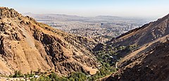
(c) Diego Delso, CC BY-SA 4.0 | |
| Państwo | |
|---|---|
| Siedziba | |
| Powierzchnia | 13 692 km² |
| Populacja (2016) • liczba ludności |
|
| • gęstość | 1021 os./km² |
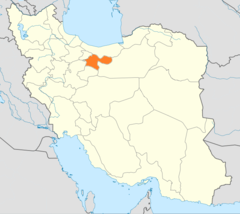
Położenie na mapie | |
Teheran – ostan w północnym Iranie, na przedgórzu gór Elburs. Stolicą jest Teheran.
Powierzchnia: 13 692 km². Liczba ludności w 2016 wyniosła 13,3 mln. Do większych miast (pod względem liczebności) należą prócz Teheranu m.in. Eslamszahr, Malard, Ghods.
Jeszcze w 1971 Iran dzielił się na 13 ostanów. W 1966 Teheran liczył 60,8 km² powierzchni 4,979 mln mieszkańców. Wtedy w ostanie uprawiano buraki cukrowe, zboża, hodowano owce i kozy; wydobywano węgiel kamienny, rudy żelaza, manganu oraz ropę naftową[1]. W 2010 roku z północno-zachodniej części ostanu wydzielono nową jednostkę administracyjną Alborz.
Przypisy
- ↑ Encyklopedia Powszechna PWN. T. 4. R-Z. Warszawa: Państwowe Wydawnictwo Naukowe, 1976, s. 427.
Media użyte na tej stronie
State emblem of the Islamic Republic of Iran. U+262B, stylized version of Arabic script of Allah (الله, with the central lam shaped to look like a sword.) The emblem is also an overlaid rendering of La Ilaha Illa Allah (There is only one God and that is 'Allah'). The exact shape of the emblem and an algorithmic ruler-and-compass construction is described in the national Iranian standard at IRANIAN ISLAMIC REPUBLIC FLAG, ISIRI 1, 1371, 3rd edition, March 1993 in Persian. The emblem was designed by Hamid Nadimi, and was officially approved by Ayatollah Khomeini on May 9, 1980.
Autor: Original work by Uwe Dering. Highlighted by Dr. Blofeld, Licencja: CC BY-SA 3.0
Locator map of Iran
State emblem of the Islamic Republic of Iran. U+262B, stylized version of Arabic script of Allah (الله, with the central lam shaped to look like a sword.) The emblem is also an overlaid rendering of La Ilaha Illa Allah (There is only one God and that is 'Allah'). The exact shape of the emblem and an algorithmic ruler-and-compass construction is described in the national Iranian standard at IRANIAN ISLAMIC REPUBLIC FLAG, ISIRI 1, 1371, 3rd edition, March 1993 in Persian. The emblem was designed by Hamid Nadimi, and was officially approved by Ayatollah Khomeini on May 9, 1980.


