Terre-de-Haut
 | |||
| |||
| Państwo | |||
|---|---|---|---|
| Departament zamorski | |||
| Okręg | |||
| Kanton | Les Saintes | ||
| Gmina | Terre-de-Haut | ||
| Powierzchnia | 5,22 km² | ||
| Populacja (2010) • liczba ludności |
| ||
| Kod pocztowy | 97137 | ||
| Strona internetowa | |||
| Portal | |||
Terre-de-Haut – miasto w Gwadelupie (Departament zamorski Francji), leżące na wyspie Terre-de-Haut należącej do archipelagu Les Saintes; 1 787 mieszkańców (2010).
Zobacz też
- Gminy Gwadelupy
Media użyte na tej stronie
Autor: Moowgly, Licencja: CC BY-SA 3.0
Cut waved, to the first one of silver for two fasces of azure with the iguana binding on the whole; in the second of azure in the fort of silver opened by sand.
The ecu is stamped by a crown of golden hulls with sails of silver and supported by two golden fishes. An anchor appears from the point to significate that the Bay is one of the most beautiful of the world.
They were adopted during the Patron saint's day of August 15th, 1979.Autor: Eric Gaba (Sting - fr:Sting), Licencja: CC BY-SA 3.0
Blank administrative map of the region and department of Guadeloupe, France, for geo-location purpose, with arrondissements boundaries.
Autor: Stéphane Batigne, Licencja: CC BY 3.0
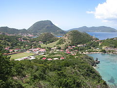
Vue de Terre-de-Haut (Les Saintes, Guadeloupe), avec le Chameau (point culminant, 309 m).


