Tewkesbury (borough)
| ||
| dystrykt niemetropolitalny | ||
 Tewkesbury | ||
| Państwo | ||
|---|---|---|
| Kraj | ||
| Region | South West England | |
| Hrabstwo | Gloucestershire | |
| Powierzchnia | 414,4 km² | |
| Populacja (2011) • liczba ludności | 81 943 | |
| • gęstość | 198[1]. os./km² | |
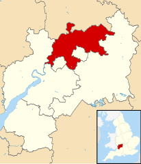
| Położenie na mapie Gloucestershire Contains Ordnance Survey data © Crown copyright and database right, CC BY-SA 3.0 | ||
| Strona internetowa | ||
| Portal | ||
Tewkesbury – dystrykt w hrabstwie Gloucestershire w Anglii[2]. W 2011 roku dystrykt liczył 81 943 mieszkańców[3].
Miasta
Inne miejscowości
Alderton, Alstone, Apperley, Ashchurch, Ashleworth, Badgeworth, Bengrove, Bishop’s Cleeve, Boddington, Brockhampton, Buckland, Chaceley, Churchdown, Deerhurst, Down Hatherley, Dumbleton, Great Washbourne, Great Witcombe, Gretton, Hardwicke, Hasfield, Highnam, Hucclecote, Innsworth, Leigh, Little Washbourne, Longford, Maisemore, Minsterworth, Northway, Norton, Over, Oxenton, Prescott, Sandhurst, Shurdington, Snowshill, Southam, Stanton, Stanway, Staverton, Stoke Orchard, Teddington, Tirley, Toddington, Tredington, Twyning, Uckington, Walton Cardiff, Woodmancote i Wormington.
Przypisy
- ↑ 2011 census results: how many people live in your local authority (ang.). The Guardian. [dostęp 2016-03-05].
- ↑ Tewkesbury (ang.). Ordnance Survey linked data. [dostęp 2016-03-05].
- ↑ Area: Tewkesbury (Local Authority) (ang.). Neighbourhood Statistics (ONS). [dostęp 2016-03-05]. [zarchiwizowane z tego adresu (2016-03-15)].
Media użyte na tej stronie
Flag of England. Saint George's cross (a red cross on a white background), used as the Flag of England, the Italian city of Genoa and various other places.
Tewkesbury Abbey, tower from south west
Contains Ordnance Survey data © Crown copyright and database right, CC BY-SA 3.0
Map of Gloucestershire, UK with Tewkesbury highlighted.
Equirectangular map projection on WGS 84 datum, with N/S stretched 160%


