Teylingen
| |||||
 | |||||
| Państwo | |||||
|---|---|---|---|---|---|
| Prowincja | Holandia Południowa | ||||
| Burmistrz | Carla Breuer (2015)[1] | ||||
| Powierzchnia | 33,49 km² | ||||
| Populacja (2014) • liczba ludności | 35 723 [2] | ||||
| Strona internetowa | |||||
Teylingen – gmina w prowincji Holandia Południowa w Holandii. Obejmuje miejscowości Sassenheim, Voorhout i Warmond.
Przypisy
- ↑ teylingen.nl: Samenstelling college B&W (niderl.). [dostęp 2021-10-03].
- ↑ Aktualna liczba mieszkańców gminy (nl) [dostęp 12 lipca 2014]
Media użyte na tej stronie
Autor: Vincent van Zeijst, Licencja: CC BY-SA 3.0
The river Zijp in the municipality of Teylingen (Province South Holland, Netherlands) is only 1 km long and forms the connection between two of the Kaag lakes: the Vennemeer and Zweiland. The picture shows the northern part of the Zijp, with houseboats on both shores, looking towards the Zijp's mouth in Kaag lake 'Zweiland'.
Coat of arms of Teylingen (Netherlands).
Flag of Teylingen
Autor: Erik Frohne, Licencja: CC BY-SA 3.0
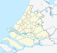
Location map of province South Holland in the Netherlands
Equirectangular projection, N/S stretching 162 %. Geographic limits of the map:
- N: 52.40° N
- S: 51.60° N
- W: 3.80° E
- E: 5.20° E


