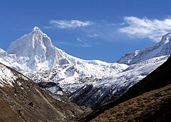
Thalay Sagar
Widok Thalaysagar z trasy na Kedartal | |
| Państwo | |
|---|---|
| Położenie | |
| Pasmo | |
| Wysokość | 6904 m n.p.m. |
| Wybitność | 1000 m |
| Pierwsze wejście | 24 czerwca 1979 |
Thalay Sagar – szczyt w Himalajach. Leży w Indiach, w stanie Uttarakhand. Należy do jednej grani razem z takimi szczytami jak Shivling, Bhrigupanth i Meru.
Pierwszego wejścia dokonali Roy Kligfield, John Thackray i Pete Thexton 24 czerwca 1979 r.
Bibliografia
- Thalay Sagar na Peakware. peakware.com. [zarchiwizowane z tego adresu (2015-04-02)].
Media użyte na tej stronie
The Flag of India. The colours are saffron, white and green. The navy blue wheel in the center of the flag has a diameter approximately the width of the white band and is called Ashoka's Dharma Chakra, with 24 spokes (after Ashoka, the Great). Each spoke depicts one hour of the day, portraying the prevalence of righteousness all 24 hours of it.
Black up-pointing triangle ▲, U+25B2 from Unicode-Block Geometric Shapes (25A0–25FF)
Autor:
- Uttarakhand_locator_map.svg: by User:Planemad
- derivative work: User:Milenioscuro
Location map of Uttarakhand Geographic limits of the map:
- 31.61°N
- 28.50°N
- 77.46°E
- 81.19°E
Autor: Uwe Dedering, Licencja: CC BY-SA 3.0
Location map of India.
Equirectangular projection. Stretched by 106.0%. Geographic limits of the map:
- N: 37.5° N
- S: 5.0° N
- W: 67.0° E
- E: 99.0° E


