The Wash
 | |
| Państwo | |
|---|---|
| Kraj | |
| Lokalizacja | |
| Cieki wodne uchodzące | |
| Miejscowości nadbrzeżne | |
Położenie na mapie Lincolnshire Contains Ordnance Survey data © Crown copyright and database right, CC BY-SA 3.0 | |
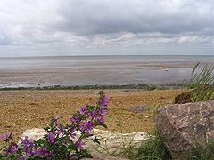
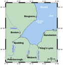
The Wash – estuarium i zatoka na wschodnim wybrzeżu Anglii (Wielka Brytania), zasilane wodami rzek Witham, Welland, Nene oraz Great Ouse. Zbliżone kształtem do kwadratu. Jest jednym z największych spośród estuariów Wielkiej Brytanii.
Media użyte na tej stronie
Autor: Alexrk2, Licencja: CC BY-SA 3.0
Location map of the United Kingdom
Flag of England. Saint George's cross (a red cross on a white background), used as the Flag of England, the Italian city of Genoa and various other places.
Contains Ordnance Survey data © Crown copyright and database right, CC BY-SA 3.0
Relief map of Lincolnshire, UK.
Equirectangular map projection on WGS 84 datum, with N/S stretched 165%
Geographic limits:
- West: 1.16W
- East: 0.39E
- North: 53.75N
- South: 52.62N
Autor: Nilfanion, Licencja: CC BY-SA 3.0
Relief map of England, UK.
Equirectangular map projection on WGS 84 datum, with N/S stretched 170%
Geographic limits:
- West: 6.75W
- East: 2.0E
- North: 56.0N
- South: 49.75N


