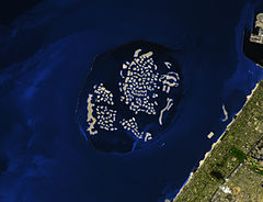
The World
 Widok na archipelag (2009) | |
| Kontynent | |
|---|---|
| Państwo | |
| Liczba wysp | ok. 300 |
| Powierzchnia | 14 000–42 000 m² km² |
Mapa | |
The World − archipelag ok. 300 sztucznych wysp, usypanych na dnie szelfu 4 km od wybrzeży Dubaju. Wyspy widziane z lotu ptaka tworzą widok mapy świata.
Zobacz też
- Al Nakheel Properties
- Wyspy Palmowe
- Dubai Waterfront
- Burdż al-Arab
- Burdż Chalifa
- Nakheel Tower
Linki zewnętrzne
- Dubai: The World Islands – The Emirates Network Real Estate. realestate.theemiratesnetwork.com. [zarchiwizowane z tego adresu (2009-12-12)].
- TheWorld – strona
- Nakheel – strona developera
Media użyte na tej stronie
Shiny LightSteelBlue button/marker widget. Used to mark the location of something such as a tourist attraction.
Autor:
- United_Arab_Emirates_location_map.svg: NordNordWest
- derivative work: Uwe Dedering (talk)
Location map of the United Arab Emirates
Autor:
- Dubai_Bauprojekte.png: Lencer
- derivative work: Stratforder (talk)
Karte der Bauprojekte in Dubai (Palm Jebel Ali, Palm Jumeirah, Palm Deira, The World, The Universe, Waterfront u.a.), Stand: 2009
The World Archipelago, Persian Gulf. The image shows the project on February 5, 2009. All the continents are represented (the “map” is tilted toward the left). A breakwater surrounds the archipelago, and its role is obvious: outside the perimeter, especially to the northwest, the waters of the Gulf ripple with waves that would wear the artificial islands away.


