Thimlich Ohinga
| ||
| Obiekt z listy światowego dziedzictwa UNESCO | ||
 | ||
| Państwo | ||
| Typ | kulturowy | |
| Spełniane kryterium | III, IV, V | |
| Numer ref. | 1450 | |
| Region[b] | Afryka | |
| Historia wpisania na listę | ||
| Wpisanie na listę | 2018 na 42. sesji | |
Położenie na mapie Kenii | ||
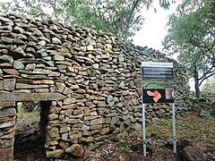
Thimlich Ohinga – stanowisko archeologiczne w zachodniej Kenii, w 2018 roku wpisane na listę światowego dziedzictwa UNESCO.
Zachowały się tu pozostałości XVI-wiecznej osady zbudowanej techniką kamienia bez zaprawy, typową w tej części świata dla pasterskich społeczności kotliny Jeziora Wiktorii. Osada służyła głównie jako schronienie dla ludzi i zwierząt i jest jedną z najlepiej zachowanych w regionie.
Bibliografia
| ||||||
Media użyte na tej stronie
Flag of the United Nations Educational, Scientific and Cultural Organization (UNESCO)
Autor: Wycondi, Licencja: CC BY-SA 3.0
Thimlich Ohinga Cultural Lanscape is situated in Migori County in Kenya. It is a dry stone walling enclosure that reaches four metres high in some sections and two metres wide covering fifty two acres of land, with smaller inner enclosures that were probably cattle kraals. The walls are over 500 years old and the architectural technique used in its construction of using dry stones meticulously arranged without use of mortare is still a mystery. At Thimlich Ohinga three massive enclosures are interlinked. That is Kochieng, Kakuku and Koluoch enclosures. The monument was gazetted as a national monument in 1981.
(c) Uwe Dedering z niemieckiej Wikipedii, CC BY-SA 3.0
Location map of Kenya
Equirectangular projection. Strechted by 100.0%. Geographic limits of the map:
- N: 6.0° N
- S: -5.0° N
- W: 33.0° E
- E: 43.0° E


